IMAGES TAKEN NEAR TO
Longden, SHREWSBURY, SY5 8EZ
Introduction
This page details the photographs taken nearby to SY5 8EZ by members of the Geograph project.
The Geograph project started in 2005 with the aim of publishing, organising and preserving representative images for every square kilometre of Great Britain, Ireland and the Isle of Man.

There are currently over 7.5m images from over14,400 individuals and you can help contribute to the project by visiting https://www.geograph.org.uk
Image Map (Loading...)


Getting Data...Please wait
Leaflet Map data © OpenStreetMap
Images are licensed for reuse under creativecommons.org/licenses/by-sa/2.0
Notes
- Clicking on the map will re-center to the selected point.
- The higher the marker number, the further away the image location is from the centre of the postcode.
Image Listing (8 Images Found)
Images are licensed for reuse under creativecommons.org/licenses/by-sa/2.0
Image
Details
Distance
1
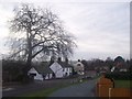
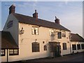
Hall Farm, Longden
Farmhouse and barns at the village's Hall Farm.
Image: © Richard Law
Taken: 8 Jun 2013
0.07 miles
2
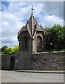
Summer House
Summer house at Hall Farm in Longden
Image: © Andrew Wood
Taken: Unknown
0.11 miles
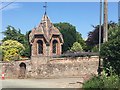
3
Summer house and garden wall
The summer house at Hall Farm in Longden
Image: © Dave Croker
Taken: 26 May 2009
0.11 miles
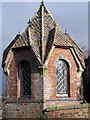
4
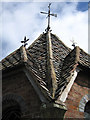
Summer house roof detail
Summer house at Hall Farm in Longden
Image: © Dave Croker
Taken: 26 May 2009
0.11 miles
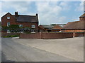
6
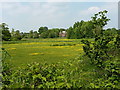
Fields of buttercups to the west of Longden
It's been a good year for the buttercups around this area - haven't seen so many for a long while. A couple of houses in the village are visible through the trees.
Image: © Richard Law
Taken: 8 Jun 2013
0.21 miles