IMAGES TAKEN NEAR TO
Church Pulverbatch, Pulverbatch, SHREWSBURY, SY5 8DD
Introduction
This page details the photographs taken nearby to SY5 8DD by members of the Geograph project.
The Geograph project started in 2005 with the aim of publishing, organising and preserving representative images for every square kilometre of Great Britain, Ireland and the Isle of Man.

There are currently over 7.5m images from over14,400 individuals and you can help contribute to the project by visiting https://www.geograph.org.uk
Image Map
Images are licensed for reuse under creativecommons.org/licenses/by-sa/2.0
Notes
- Clicking on the map will re-center to the selected point.
- The higher the marker number, the further away the image location is from the centre of the postcode.
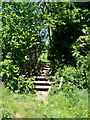
Image Listing (5 Images Found)
Images are licensed for reuse under creativecommons.org/licenses/by-sa/2.0
Image
Details
Distance
2
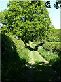
Ford and footbridge over a tributary of the Cound Brook
Image: © Richard Law
Taken: 23 May 2010
0.13 miles
3
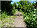
Ford at Holly Grove Farm
This ford is found on a bridleway beside Holly Grove Farm.
Image: © John Walton
Taken: 24 Oct 2015
0.13 miles
5
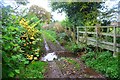
Footbridge over a stream
The maps all mark this route as a bridleway, but the signage on the ground (and this footbridge) suggest it may have been downgraded to a footpath. I wasn't going to let that stop me riding a bike along it.
Image: © Richard Law
Taken: 23 May 2010
0.24 miles