IMAGES TAKEN NEAR TO
Hookagate, SHREWSBURY, SY5 8BA
Introduction
This page details the photographs taken nearby to SY5 8BA by members of the Geograph project.
The Geograph project started in 2005 with the aim of publishing, organising and preserving representative images for every square kilometre of Great Britain, Ireland and the Isle of Man.

There are currently over 7.5m images from over14,400 individuals and you can help contribute to the project by visiting https://www.geograph.org.uk
Image Map
Images are licensed for reuse under creativecommons.org/licenses/by-sa/2.0
Notes
- Clicking on the map will re-center to the selected point.
- The higher the marker number, the further away the image location is from the centre of the postcode.
Image Listing (7 Images Found)
Images are licensed for reuse under creativecommons.org/licenses/by-sa/2.0
Image
Details
Distance
1
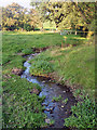
Almost hidden stream
Driving into Hook-a-Gate village it's all to easy to miss this view.
Image: © Row17
Taken: 13 Oct 2010
0.03 miles
2
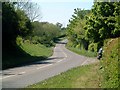
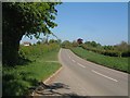
Longden road at Hook-a-gate
Longden Road, View south-west from Hook-a-gate
Image: © Andrew Bennett
Taken: 1 May 2007
0.04 miles
3
Path down to Hook-a-gate village
Let's wander down there...
Image: © Jeremy Bolwell
Taken: 17 Jan 2021
0.16 miles
4
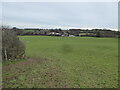
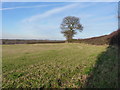
Hook-a-gate
Southern end of village of Hook-a-gate.
This grid square is almost entirely agricultural land.
Image: © Andrew Bennett
Taken: 1 May 2007
0.18 miles
5
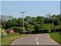
Longden Road at Welbatch
This grid square is mostly agricultural, with a few dwellings and farms.
Image: © Andrew Bennett
Taken: 1 May 2007
0.18 miles
7
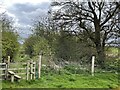
Welbatch Pit Mound, near Hook-a-Gate
Remains of a coal mine tramway is just discernible in the trees at the side of the footpath.
Image: © Andrew Shannon
Taken: 14 Apr 2022
0.22 miles