IMAGES TAKEN NEAR TO
Upper Longwood, SHREWSBURY, SY5 6SB
Introduction
This page details the photographs taken nearby to Upper Longwood, SY5 6SB by members of the Geograph project.
The Geograph project started in 2005 with the aim of publishing, organising and preserving representative images for every square kilometre of Great Britain, Ireland and the Isle of Man.

There are currently over 7.5m images from over14,400 individuals and you can help contribute to the project by visiting https://www.geograph.org.uk
Image Map (Loading...)


Getting Data...Please wait
Leaflet Map data © OpenStreetMap
Images are licensed for reuse under creativecommons.org/licenses/by-sa/2.0
Notes
- Clicking on the map will re-center to the selected point.
- The higher the marker number, the further away the image location is from the centre of the postcode.
Image Listing (11 Images Found)
Images are licensed for reuse under creativecommons.org/licenses/by-sa/2.0
Image
Details
Distance
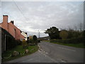
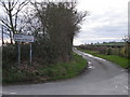
4
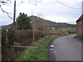
Upper Longwood - road junction
Post box SY5 221 makes an appearance in the triangle of the road junction leading towards Neves Castle.
Image: © Richard Law
Taken: 26 Sep 2010
0.04 miles
6
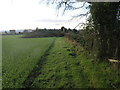
Two Trees
Upper Longwood has lost one of its trees in the recent gales.
Image: © Michael Patterson
Taken: 24 Jan 2007
0.08 miles
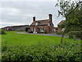
10
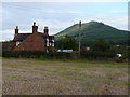
Cottage at Upper Longwood
A small cottage just north of Longwood Farm, with a view of the Wrekin (and a lot of power lines)
Image: © Richard Law
Taken: 26 Sep 2010
0.15 miles