IMAGES TAKEN NEAR TO
Garmston, Eaton Constantine, SHREWSBURY, SY5 6RL
Introduction
This page details the photographs taken nearby to SY5 6RL by members of the Geograph project.
The Geograph project started in 2005 with the aim of publishing, organising and preserving representative images for every square kilometre of Great Britain, Ireland and the Isle of Man.

There are currently over 7.5m images from over14,400 individuals and you can help contribute to the project by visiting https://www.geograph.org.uk
Image Map
Images are licensed for reuse under creativecommons.org/licenses/by-sa/2.0
Notes
- Clicking on the map will re-center to the selected point.
- The higher the marker number, the further away the image location is from the centre of the postcode.
Image Listing (17 Images Found)
Images are licensed for reuse under creativecommons.org/licenses/by-sa/2.0
Image
Details
Distance
1
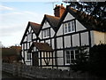
Orchard Cottage
Orchard Cottage - a Grade II listed 17th-Century cottage. Listing: https://historicengland.org.uk/listing/the-list/list-entry/1175627?section=official-list-entry
Image: © Andrew Abbott
Taken: 22 Dec 2022
0.04 miles
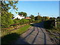
2
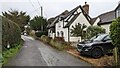
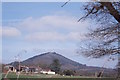
Garmston, looking towards The Rudge
Near the centre of the village.
Image: © Andrew Abbott
Taken: 22 Dec 2022
0.05 miles
3
Holly Cottage, Garmston
Thatched cottage
Image: © Andrew Abbott
Taken: 22 Dec 2022
0.05 miles
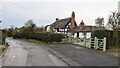
6
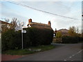
Finger-post in Garmston with The Wrekin in the background.
Image: © Row17
Taken: 2 Mar 2008
0.07 miles
7
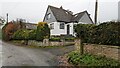
Homestead house
Private house - was previously red brick (2009).
Image: © Andrew Abbott
Taken: 22 Dec 2022
0.07 miles
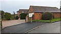
10
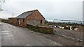
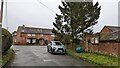
Barn conversion at Garmston Smithy
Planning permission was recently granted to convert this into a residential building.
There is some evidence to indicate the smaller building was a later addition to the Site based on historical maps. Tithe maps dating from 1846 show that the Smithy and the pictured barn were both in the ownership of the Duke of Cleveland and occupied by Samuel Edge.
Image: © Andrew Abbott
Taken: 22 Dec 2022
0.16 miles