IMAGES TAKEN NEAR TO
Wroxeter, SHREWSBURY, SY5 6PH
Introduction
This page details the photographs taken nearby to SY5 6PH by members of the Geograph project.
The Geograph project started in 2005 with the aim of publishing, organising and preserving representative images for every square kilometre of Great Britain, Ireland and the Isle of Man.

There are currently over 7.5m images from over14,400 individuals and you can help contribute to the project by visiting https://www.geograph.org.uk
Image Map
Images are licensed for reuse under creativecommons.org/licenses/by-sa/2.0
Notes
- Clicking on the map will re-center to the selected point.
- The higher the marker number, the further away the image location is from the centre of the postcode.
Image Listing (66 Images Found)
Images are licensed for reuse under creativecommons.org/licenses/by-sa/2.0
Image
Details
Distance
1

Glebe Cottage, Wroxeter
To be fair, I missed the important part of this cottage in the photo - the black and white portion at the rear and at the left gable is much older and more interesting than the 18th/19th century brick frontage mostly seen here. The rearwards part dates back to the 15th or 16th century, being interpreted as the remaining fragment of a much larger open hall-house, and built of cruck-frame construction, with a series of period features both internally and externally which give clues to its age and origins. It was Grade II listed https://britishlistedbuildings.co.uk/101224481-glebe-cottage-wroxeter-and-uppington#.YO8Q3uhKjIU & https://historicengland.org.uk/listing/the-list/list-entry/1224481 in 1985.
Image: © Richard Law
Taken: 12 Jul 2020
0.02 miles
2
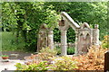
Wroxeter Sham Ruin
A sham ruin, probably 19th century, constructed from Roman and possibly medieval remnants.
Image: © Alan Terrill
Taken: 18 Jun 2013
0.04 miles
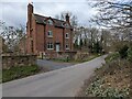
3
Wroxeter Grange
A rather fine and substantial house which dates back to 1690, albeit with alterations in the meantime. It was Grade II listed https://britishlistedbuildings.co.uk/101266671-wroxeter-grange-wroxeter-and-uppington#.YO8VBehKjIU & https://historicengland.org.uk/listing/the-list/list-entry/1266671 in 1985.
Image: © Richard Law
Taken: 12 Jul 2020
0.05 miles
4
NEW
6-7 Mount Pleasant, Wroxeter
It looks better from the front. This large house is likely to be undergoing extensive renovation, as it has recently been sold and the interior needs a lot of work. Sold for c. £575,000. More information at: https://web.archive.org/web/20250313132626/https://www.rightmove.co.uk/properties/145604609#/?channel=RES_BUY
Image: © TCExplorer
Taken: 13 Mar 2025
0.05 miles
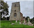
6

Wroxeter The Church of St Andrew
Detail of ancient (Saxon?) stonework incorporated into the 18th century work
Image: © Michael Garlick
Taken: 14 Apr 2014
0.05 miles
7
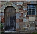
Wroxeter The Church of St Andrew
Door and window constructed of stone in a multitude of different colours
Image: © Michael Garlick
Taken: 14 Apr 2014
0.05 miles

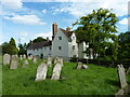
9
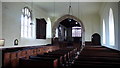
Interior of St. Andrews Church, Wroxeter
Maintained under the Redundant Churches Fund, St. Andrews Church is of historical interest both inside and out. Built using stone from the Roman remains of Viroconium the interior is also notable for its box pews dating from the 17th/18th Century. Oldest relic is a 14th Century chest.
Image: © Peter Comeau
Taken: 5 Oct 2009
0.06 miles
10

St Andrew's Church, Wroxeter
St Andrew's church contains some fine memorials. The church is Grade I listed, see: http://www.geograph.org.uk/submit2.php?multi=true#gridref=SJ%205646%200869
Image: © Philip Halling
Taken: 18 May 2018
0.06 miles