IMAGES TAKEN NEAR TO
Cantlop, Cross Houses, SHREWSBURY, SY5 6HQ
Introduction
This page details the photographs taken nearby to SY5 6HQ by members of the Geograph project.
The Geograph project started in 2005 with the aim of publishing, organising and preserving representative images for every square kilometre of Great Britain, Ireland and the Isle of Man.

There are currently over 7.5m images from over14,400 individuals and you can help contribute to the project by visiting https://www.geograph.org.uk
Image Map (Loading...)


Getting Data...Please wait
Leaflet Map data © OpenStreetMap
Images are licensed for reuse under creativecommons.org/licenses/by-sa/2.0
Notes
- Clicking on the map will re-center to the selected point.
- The higher the marker number, the further away the image location is from the centre of the postcode.
Image Listing (26 Images Found)
Images are licensed for reuse under creativecommons.org/licenses/by-sa/2.0
Image
Details
Distance
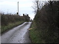
1
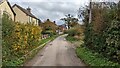
Lane and houses in Cantlop
Looking east along the cul-de-sac lane in Cantlop.
Image: © Andrew Abbott
Taken: 25 Oct 2022
0.01 miles
2
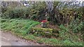
Cantlop pump
The old pump in Cantlop. Manufactured by Joseph Evans & Sons (Wolverhampton) Limited. The pump is listed - its listing states "Village pump and trough. Mid-to late C19. Cast iron pump; circular shaft with moulded rings, fluted top with splayed spout, and fluted domed cap with finial; curved handle; cast maker plate inscribed : "LION /...... / WOLVERHAMPTON". Grey sandstone trough with rounded front corners. Numbers 66 and 72 are not included in this list."
https://historicengland.org.uk/listing/the-list/list-entry/1366714
Image: © Andrew Abbott
Taken: 25 Oct 2022
0.01 miles
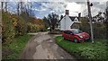
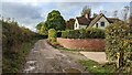
3
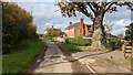
72 Cantlop
Cottage in Cantlop, just past the old oak tree.
Image: © Andrew Abbott
Taken: 25 Oct 2022
0.01 miles
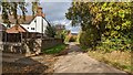
4
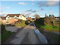
Cantlop village
This part of Cantlop is a small hamlet of houses and farm buildings, at the end of a short dead-end lane.
Image: © Richard Law
Taken: 7 Nov 2015
0.01 miles
6
69 and 70 Cantlop
"A farmhouse that was extended in the 19th century, the original part is timber framed and rendered, and the extension is rendered; the roof is tiled. There are two storeys and attics, the front facing the road has two bays, and behind it is an extension, forming a T-shaped plan. On the front is a doorway with a moulded architrave, a fanlight, and a cornice. The windows are cross-windows with moulded architraves and hood moulds. In the rear wing, most of the windows are casements, there is a sash window and gabled dormers with bargeboards."
More info: https://historicengland.org.uk/listing/the-list/list-entry/1055548
Image: © Andrew Abbott
Taken: 25 Oct 2022
0.05 miles
7
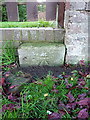
OS benchmark - Cantlop
An OS cutmark at the base of a garden wall in the village; originally levelled at 86.021m above Ordnance Datum Newlyn.
Image: © Richard Law
Taken: 7 Nov 2015
0.05 miles
8
69 and 70 Cantlop
Another view of 69 and 70, Cantlop. Also see another view at Image
"A farmhouse that was extended in the 19th century, the original part is timber framed and rendered, and the extension is rendered; the roof is tiled. There are two storeys and attics, the front facing the road has two bays, and behind it is an extension, forming a T-shaped plan. On the front is a doorway with a moulded architrave, a fanlight, and a cornice. The windows are cross-windows with moulded architraves and hood moulds. In the rear wing, most of the windows are casements, there is a sash window and gabled dormers with bargeboards."
More info: https://historicengland.org.uk/listing/the-list/list-entry/1055548
Image: © Andrew Abbott
Taken: 25 Oct 2022
0.06 miles
9
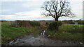
Start of byway from Cantlop to Cantlop Mill
Start of byway from Cantlop to Cantlop Mill, nice iron gate to field entrance on the right
Image: © Rob Bainbridge
Taken: 6 Jan 2023
0.09 miles
10
Whiteacre house in Cantlop
Looking south-west from the end of the lane towards Whiteacre
Image: © Andrew Abbott
Taken: 25 Oct 2022
0.09 miles