IMAGES TAKEN NEAR TO
Cound Moor, Cound, SHREWSBURY, SY5 6BB
Introduction
This page details the photographs taken nearby to SY5 6BB by members of the Geograph project.
The Geograph project started in 2005 with the aim of publishing, organising and preserving representative images for every square kilometre of Great Britain, Ireland and the Isle of Man.

There are currently over 7.5m images from over14,400 individuals and you can help contribute to the project by visiting https://www.geograph.org.uk
Image Map
Images are licensed for reuse under creativecommons.org/licenses/by-sa/2.0
Notes
- Clicking on the map will re-center to the selected point.
- The higher the marker number, the further away the image location is from the centre of the postcode.
Image Listing (10 Images Found)
Images are licensed for reuse under creativecommons.org/licenses/by-sa/2.0
Image
Details
Distance
2
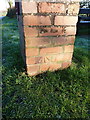
OS benchmark - Coundmoor, letterbox
A rather odd OS benchmark on the brick construction containing the village letterbox seen in Image The mis-alignment of the arrow and the datum mark suggest that the pillar has been rebuilt at some stage, and the bricks weren't put back in the same places.
Image: © Richard Law
Taken: 4 Jan 2015
0.09 miles
3
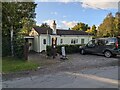
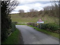
Coundmoor
Pretty much the centre of the village, with the Village Hall prominent on the other side of the road.
Image: © Richard Law
Taken: 4 Jan 2015
0.10 miles
4
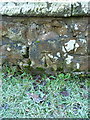
OS benchmark - Coundmoor, bridge
An OS cutmark on the SE side of the bridge over the brook; originally levelled at 92.675m above Ordnance Datum Newlyn.
Image: © Richard Law
Taken: 4 Jan 2015
0.12 miles
5
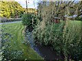
Coundmoor Brook / Bullhill Brook at Evenwood
Confusingly, OS mapping appears to have two names for this water course, and I'm not clear when it changes:
* Coundmoor Brook
or
*Bullhill Brook
Image: © TCExplorer
Taken: 11 Sep 2024
0.13 miles
7
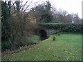
Bridge over brook
This brook marks the boundary between Evenwood (to the left) and Coundmoor (this side), although both settlements together would struggle to make a hamlet!
Image: © Jennifer Luther Thomas
Taken: 1 Dec 2006
0.15 miles
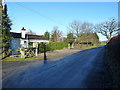
8
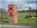
Postbox & Village Pump - Victorian necessities
Image: © Row17
Taken: 26 Mar 2008
0.17 miles
9
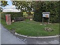
Coundmoor village noticeboard and postbox
Ther'es also a village pump in the corner, although it isn't marked on any historical Ordnance Survey maps I've seen.
Image: © TCExplorer
Taken: 11 Sep 2024
0.17 miles
10
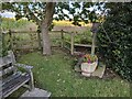
Coundmoor Village Pump
The pump isn't marked on any historical Ordnance Survey maps I've seen.
Image: © TCExplorer
Taken: 11 Sep 2024
0.18 miles