IMAGES TAKEN NEAR TO
Cound, SHREWSBURY, SY5 6AW
Introduction
This page details the photographs taken nearby to SY5 6AW by members of the Geograph project.
The Geograph project started in 2005 with the aim of publishing, organising and preserving representative images for every square kilometre of Great Britain, Ireland and the Isle of Man.

There are currently over 7.5m images from over14,400 individuals and you can help contribute to the project by visiting https://www.geograph.org.uk
Image Map (20 Images)


Getting Data...Please wait
Leaflet Map data © OpenStreetMap
Images are licensed for reuse under creativecommons.org/licenses/by-sa/2.0
Notes
- Clicking on the map will re-center to the selected point.
- The higher the marker number, the further away the image location is from the centre of the postcode.
Image Listing (20 Images Found)
Images are licensed for reuse under creativecommons.org/licenses/by-sa/2.0
Image
Details
Distance
1
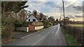
Sandyfields and Coundarbour Farm
Looking north towards Sandyfields and Coundarbour Farm
Image: © Andrew Abbott
Taken: 20 Dec 2022
0.02 miles
4
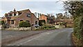
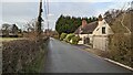
Mill Cottage, Coundarbour
The Grade II listed Mill Cottage, Coundarbour.
Official listing (https://historicengland.org.uk/listing/the-list/list-entry/1366719?section=official-list-entry) states: II Cottage. Probably early to mid-C17 with mid-C20 addition and alterations. Rendered timber frame and masonry; plain tile roof. Two framed bays with addition. Central gabled eaves dormer with two-light diamond-leaded casement; one C17 and one C20 gabled eaves dormer at rear, both timber framed with C20 two-light diamond-leaded casements; brick ridge stack off-centre to left and C20 external brick end stack to left. Three-window front; C20 two- and three-light diamond-leaded casements and C20 hipped canted bay to right with diamond-leaded casements; boarded door between first and second windows from left with hipped timber porch.
Image: © Andrew Abbott
Taken: 20 Dec 2022
0.11 miles
5
Mill Cottage, Coundarbour
The Grade II listed Mill Cottage, Coundarbour.
Official listing (https://historicengland.org.uk/listing/the-list/list-entry/1366719?section=official-list-entry) states: II Cottage. Probably early to mid-C17 with mid-C20 addition and alterations. Rendered timber frame and masonry; plain tile roof. Two framed bays with addition. Central gabled eaves dormer with two-light diamond-leaded casement; one C17 and one C20 gabled eaves dormer at rear, both timber framed with C20 two-light diamond-leaded casements; brick ridge stack off-centre to left and C20 external brick end stack to left. Three-window front; C20 two- and three-light diamond-leaded casements and C20 hipped canted bay to right with diamond-leaded casements; boarded door between first and second windows from left with hipped timber porch.
Image: © Andrew Abbott
Taken: 20 Dec 2022
0.11 miles
6
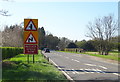
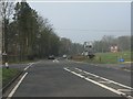
A458 towards Shrewsbury
Looking north west from Cound Bridge.
Image: © JThomas
Taken: 28 Mar 2019
0.12 miles
7
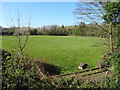
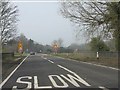
Grazing near the Cound Brook
View from Cound Bridge.
Image: © JThomas
Taken: 28 Mar 2019
0.16 miles
9
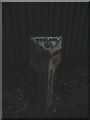
Milepost by old railway bridge
Below "SALOP 6" the legend says "TO THE COUNTY HALL".
Image: © Jennifer Luther Thomas
Taken: 1 Dec 2006
0.20 miles
10
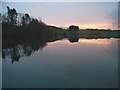
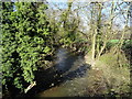
Sunset near Venusbank
The Cound Trout Fishery.
Image: © Jennifer Luther Thomas
Taken: 1 Dec 2006
0.21 miles