IMAGES TAKEN NEAR TO
The Townsend, SHREWSBURY, SY5 6AU
Introduction
This page details the photographs taken nearby to The Townsend, SY5 6AU by members of the Geograph project.
The Geograph project started in 2005 with the aim of publishing, organising and preserving representative images for every square kilometre of Great Britain, Ireland and the Isle of Man.

There are currently over 7.5m images from over14,400 individuals and you can help contribute to the project by visiting https://www.geograph.org.uk
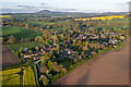
Image Map
Images are licensed for reuse under creativecommons.org/licenses/by-sa/2.0
Notes
- Clicking on the map will re-center to the selected point.
- The higher the marker number, the further away the image location is from the centre of the postcode.
Image Listing (27 Images Found)
Images are licensed for reuse under creativecommons.org/licenses/by-sa/2.0
Image
Details
Distance
1

Black and white timber-framed house at Upper Cound
Nice gable end.
Image: © Jeremy Bolwell
Taken: 31 Jan 2021
0.02 miles
2
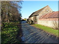
Barns at Glebe Farm
The first set of buildings coming into Upper Cound from the southeast, this is Glebe Farm.
Image: © Richard Law
Taken: 4 Jan 2015
0.03 miles
3
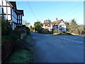
Upper Cound
The centre of the village has an unfair selection of historic and picturesque cottages.
Image: © Richard Law
Taken: 4 Jan 2015
0.05 miles
5
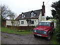
Timber framed cottage at Upper Cound
Nice place. Obviously occupied by a gentleman of distinction as there is a Chelsea mug in the window and a Land Rover on the parking spot, plus the aged caravan of course, which looks ready to head out once more soon.
Image: © Jeremy Bolwell
Taken: 31 Jan 2021
0.11 miles
6
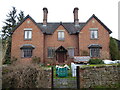
Victorian house in Upper Cound
Dated 1851. What a beaut.
Image: © Jeremy Bolwell
Taken: 31 Jan 2021
0.12 miles
7
Snowdrops beside the footpath at Upper Cound
This time of year is the very optimum time to appreciate these amazing tiny blooms.
Image: © Jeremy Bolwell
Taken: 31 Jan 2021
0.12 miles
8
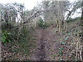
Sunken way between Cound and Upper Cound
A well old path.
Image: © Jeremy Bolwell
Taken: 31 Jan 2021
0.13 miles
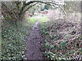
9
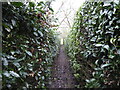
Footpath between gardens in Upper Cound
Pretty narrow.
Image: © Jeremy Bolwell
Taken: 31 Jan 2021
0.13 miles
10
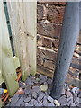
OS benchmark - Cound Farm
A rather badly damaged, and partially obscured, OS cutmark on the wall of one of the farm's barns, now converted to residential use. The mark was originally levelled at 54.401m above Ordnance Datum Newlyn.
Image: © Richard Law
Taken: 4 Jan 2015
0.14 miles