IMAGES TAKEN NEAR TO
Top Road, Pontesbury Hill, SHREWSBURY, SY5 0YE
Introduction
This page details the photographs taken nearby to Top Road, Pontesbury Hill, SY5 0YE by members of the Geograph project.
The Geograph project started in 2005 with the aim of publishing, organising and preserving representative images for every square kilometre of Great Britain, Ireland and the Isle of Man.

There are currently over 7.5m images from over14,400 individuals and you can help contribute to the project by visiting https://www.geograph.org.uk
Image Map
Images are licensed for reuse under creativecommons.org/licenses/by-sa/2.0
Notes
- Clicking on the map will re-center to the selected point.
- The higher the marker number, the further away the image location is from the centre of the postcode.
Image Listing (6 Images Found)
Images are licensed for reuse under creativecommons.org/licenses/by-sa/2.0
Image
Details
Distance
1
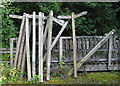
New finger posts
These new posts are waiting to be taken to their new locations in Shropshire,
this will be done by the Shropshire Access Maintenance Team based at Old Nills Quarry.
Image: © Dave Croker
Taken: 9 Sep 2009
0.07 miles
2
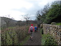
Path at the end of Whitwell Lane, Pontesbury
Walkers on the 2020 Pontesbury Potter potter along near the start of the 13 mile route.
It is an ironically named charity walk, the opposite of a potter', more of a 'challenge', comprising lots of ascent and descent on little known and little used tracks, paths and byways and after the recent rains, in often deep mud a massive effort to complete for walkers with a very wide range of fitness levels, ages and abilities.
Image: © Jeremy Bolwell
Taken: 7 Mar 2020
0.16 miles
4
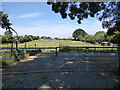
Paddocks near Pontesbury
A large equestrian property.
Image: © Jeremy Bolwell
Taken: 23 Jun 2021
0.21 miles
5
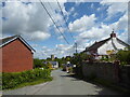
View to the church in Pontesbury
A distinct tower.
Image: © Jeremy Bolwell
Taken: 17 May 2021
0.23 miles