IMAGES TAKEN NEAR TO
Jubilee Cottages, SHREWSBURY, SY5 0RT
Introduction
This page details the photographs taken nearby to Jubilee Cottages, SY5 0RT by members of the Geograph project.
The Geograph project started in 2005 with the aim of publishing, organising and preserving representative images for every square kilometre of Great Britain, Ireland and the Isle of Man.

There are currently over 7.5m images from over14,400 individuals and you can help contribute to the project by visiting https://www.geograph.org.uk
Image Map
Images are licensed for reuse under creativecommons.org/licenses/by-sa/2.0
Notes
- Clicking on the map will re-center to the selected point.
- The higher the marker number, the further away the image location is from the centre of the postcode.
Image Listing (35 Images Found)
Images are licensed for reuse under creativecommons.org/licenses/by-sa/2.0
Image
Details
Distance
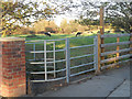
1
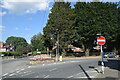
Village road junction
The A488 bifurcates into a one-way system here and merges back into one the other side of the church. There are plenty of no entry signs and road markings to keep traffic on the right road.
Image: © Bill Harrison
Taken: 19 Jul 2021
0.02 miles
2
A488 approaching Minsterley Road
The west end of the one way system
Image: © John Firth
Taken: 26 Sep 2013
0.02 miles
3
Pontesbury takeaways
Chinese or Indian... ?
Image: © Bill Harrison
Taken: 19 Jul 2021
0.02 miles
5
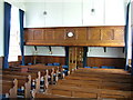
Interior of Pontesbury Congregational Church facing East
Image: © Roy Haworth
Taken: 11 Jun 2011
0.07 miles
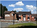
6
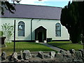
Pontesbury Congregational Church
Originally Pontesbury Independent Chapel,this chapel was built in 1839 by Independents who formerly worshipped at Plealey and at Minsterley Independent chapel. The chapel is at the centre of the range, with a Sunday School at one end and the manse at the other end. The chapel was renovated and enlarged in 1871. It is still in use as a Congregational chapel today but the noticeboard now refers to the building as a church. It is a Grade II listed building.
Image: © Roy Haworth
Taken: 11 Jun 2011
0.07 miles
7
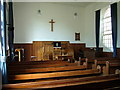
Interior of Pontesbury Congregational Church
Image: © Roy Haworth
Taken: 11 Jun 2011
0.08 miles
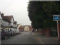
8
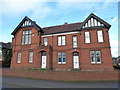
The old police station in Pontesbury
The new one is over the road.
Image: © Jeremy Bolwell
Taken: 6 Dec 2019
0.09 miles
9
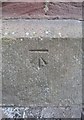
Ordnance Survey Cut Mark
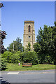
This OS cut mark can be found on the south face of St George's Church. It marks a point 111.698m above mean sea level.
Image: © Adrian Dust
Taken: 12 May 2016
0.11 miles