IMAGES TAKEN NEAR TO
David Avenue, SHREWSBURY, SY5 0QB
Introduction
This page details the photographs taken nearby to David Avenue, SY5 0QB by members of the Geograph project.
The Geograph project started in 2005 with the aim of publishing, organising and preserving representative images for every square kilometre of Great Britain, Ireland and the Isle of Man.

There are currently over 7.5m images from over14,400 individuals and you can help contribute to the project by visiting https://www.geograph.org.uk
Image Map
Images are licensed for reuse under creativecommons.org/licenses/by-sa/2.0
Notes
- Clicking on the map will re-center to the selected point.
- The higher the marker number, the further away the image location is from the centre of the postcode.
Image Listing (27 Images Found)
Images are licensed for reuse under creativecommons.org/licenses/by-sa/2.0
Image
Details
Distance
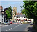
1
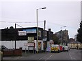
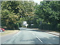
Pontesbury Public Hall and the A488 in the village
Image: © David Smith
Taken: 29 Nov 2014
0.10 miles
3
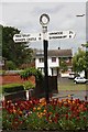
Old Direction Sign - Signpost by the A488, Main Road, Pontesbury
Annulus finial - 2 arms; Shropshire CC modern halo by the UC road, in parish of Minsterley (Shrewsbury and Atcham District), Pontesbury, in triangular flower bed.
Surveyed
Milestone Society National ID: SA_SJ4006
Image: © Milestone Society
Taken: Unknown
0.15 miles
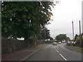
5
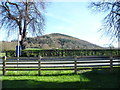
Pontesford Hill
A lovely hill that is different from every angle.
Image: © Jeremy Bolwell
Taken: 6 Apr 2015
0.16 miles
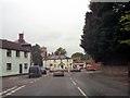
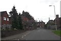
7
Pontesbury - Red Lion Inn and St Georges Church
Pontesbury, showing Red Lion Inn and the tower of St Georges Church beyond.
To the left of the Inn is Deanery Close, and to the right is Hall Bank.
Image: © Andrew Bennett
Taken: 17 Jul 2002
0.16 miles
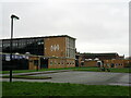
10
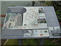
Information board on local mines at the Nags Head, Pontesbury
I had not noticed this info board until today, packed as it is with the history of local mine workings.
Image: © Jeremy Bolwell
Taken: 28 Apr 2021
0.17 miles