IMAGES TAKEN NEAR TO
Pelham Road, SHREWSBURY, SY4 4UA
Introduction
This page details the photographs taken nearby to Pelham Road, SY4 4UA by members of the Geograph project.
The Geograph project started in 2005 with the aim of publishing, organising and preserving representative images for every square kilometre of Great Britain, Ireland and the Isle of Man.

There are currently over 7.5m images from over14,400 individuals and you can help contribute to the project by visiting https://www.geograph.org.uk
Image Map
Images are licensed for reuse under creativecommons.org/licenses/by-sa/2.0
Notes
- Clicking on the map will re-center to the selected point.
- The higher the marker number, the further away the image location is from the centre of the postcode.
Image Listing (38 Images Found)
Images are licensed for reuse under creativecommons.org/licenses/by-sa/2.0
Image
Details
Distance
1
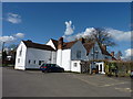
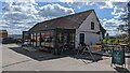
The Haughmond, Upton Magna
Formerly known as Upton Magna's village pub (called Corbet Arms) this fine hotel/restaurant is now named after the nearby Haughmond Hill and describes itself as a modern coaching inn.
Image: © James Allan
Taken: 31 Mar 2016
0.06 miles
2
The Haughmond pub at Upton Magna
Previously called the Corbet Arms I believe. Looks really nice.
Image: © Jeremy Bolwell
Taken: 11 Sep 2019
0.06 miles
3
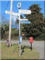
Old Direction Sign - Signpost by Pelham Road, Upton Magna
Annulus finial - 4 arms; Shropshire CC modern halo by the UC road, in parish of Upton Magna (Shrewsbury and Atcham District), Upton Magna, crossroads East of village centre.
Surveyed
Milestone Society National ID: SA_SJ5512
Image: © Milestone Society
Taken: Unknown
0.07 miles
4
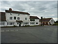
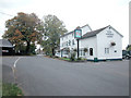
The Haughmond, Upton Magna
Formerly the Corbet Arms pub, and probably the social centre of the village.
Image: © Richard Law
Taken: 21 Jul 2020
0.07 miles
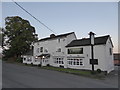
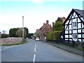
6
The Corbet Arms
Village Inn in the Shropshire village of Upton Magna.
Image: © Dennis Turner
Taken: 18 Oct 2005
0.08 miles
8
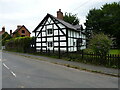
The Corner House, Upton Magna
Late 17th century in origin, but much altered in the 19th. It was Grade II listed https://britishlistedbuildings.co.uk/101222751-the-corner-house-upton-magna#.YjuOCOfP3IU & https://historicengland.org.uk/listing/the-list/list-entry/1222751 in 1972.
Image: © Richard Law
Taken: 21 Jul 2020
0.15 miles
9
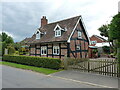
No 8, Upton Magna
Dating mainly from the 17th century, but with extensive 20th century additions and alterations, including the dormer windows. There is apparently a cruck truss construction supporting the roof internally, which is not visible from the outside. Grade II listed https://britishlistedbuildings.co.uk/101239510-8-upton-magna-upton-magna#.YjwkQ-fP02w & https://historicengland.org.uk/listing/the-list/list-entry/1239510 in 1972.
Image: © Richard Law
Taken: 21 Jul 2020
0.16 miles
10
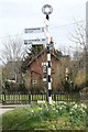
Old Direction Sign - Signpost, Upton Magna village
Annulus finial - 3 arms; Shropshire CC modern halo by the UC road, in parish of Upton Magna (Shrewsbury and Atcham District), centre of Upton Magna village, grass island.
Surveyed
Milestone Society National ID: SA_SJ5512A
Image: © Milestone Society
Taken: Unknown
0.16 miles