IMAGES TAKEN NEAR TO
Valeswood, Little Ness, SHREWSBURY, SY4 2LH
Introduction
This page details the photographs taken nearby to SY4 2LH by members of the Geograph project.
The Geograph project started in 2005 with the aim of publishing, organising and preserving representative images for every square kilometre of Great Britain, Ireland and the Isle of Man.

There are currently over 7.5m images from over14,400 individuals and you can help contribute to the project by visiting https://www.geograph.org.uk
Image Map
Images are licensed for reuse under creativecommons.org/licenses/by-sa/2.0
Notes
- Clicking on the map will re-center to the selected point.
- The higher the marker number, the further away the image location is from the centre of the postcode.
Image Listing (6 Images Found)
Images are licensed for reuse under creativecommons.org/licenses/by-sa/2.0
Image
Details
Distance
1
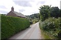
Valeswood Lane
Heading towards Nesscliffe in sandstone country.
Image: © Richard Webb
Taken: 31 Jul 2016
0.14 miles
2
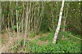
Vales Wood
Chestnut coppice on sandy soil.
Image: © Richard Webb
Taken: 31 Jul 2016
0.15 miles
3
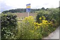
Building plot, Valeswood Lane
Between Little Ness and Nesscliffe with a view.
Image: © Richard Webb
Taken: 31 Jul 2016
0.15 miles
4
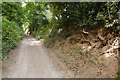
Road, The Cliffe
Leads up to a parking area which locals are still using, with admirable common sense despite a new No-tice appearing at the end. There is very little available parking on Valeswood Road.
Image: © Richard Webb
Taken: 31 Jul 2016
0.20 miles
5
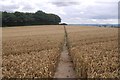
Wheat field, Valeswood
The path reveals dry sandy soil. It was to rain a lot the following week.
Image: © Richard Webb
Taken: 31 Jul 2016
0.20 miles
6
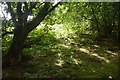
Woodland, The Cliffe
Much of the hill is now wooded, but only Wrekin Orienteers' fine map shows this. The map can usually be found on Wrekin Orienteers' routegadget site.
Image: © Richard Webb
Taken: 31 Jul 2016
0.23 miles