IMAGES TAKEN NEAR TO
Ruyton XI Towns, SHREWSBURY, SY4 1NB
Introduction
This page details the photographs taken nearby to SY4 1NB by members of the Geograph project.
The Geograph project started in 2005 with the aim of publishing, organising and preserving representative images for every square kilometre of Great Britain, Ireland and the Isle of Man.

There are currently over 7.5m images from over14,400 individuals and you can help contribute to the project by visiting https://www.geograph.org.uk
Image Map
Images are licensed for reuse under creativecommons.org/licenses/by-sa/2.0
Notes
- Clicking on the map will re-center to the selected point.
- The higher the marker number, the further away the image location is from the centre of the postcode.
Image Listing (5 Images Found)
Images are licensed for reuse under creativecommons.org/licenses/by-sa/2.0
Image
Details
Distance
1
Houses at the northern end of The Cliffe
This is the approach to the bridlepath that leads up onto The Cliffe.
Image: © John Haynes
Taken: 30 Aug 2007
0.05 miles
2
The bridlepath down from The Cliffe
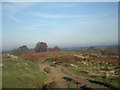
The Cliffe is a sandstone outcrop which is a common. Natural England are trying to maintain a good heathland structure, encouraging heathers and lings and suppressing bracken and birch scrub by cutting. It is hoped to provide a good habitat for the rarer heathland insects.
Image: © John Haynes
Taken: 30 Aug 2007
0.13 miles
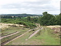
4
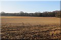
Stubble
Field at the back of The Cliffe, Ruyton XI Towns. Winter stubble is not a common sight now in England due to the prevalence of winter cereals.
Image: © Richard Webb
Taken: 28 Dec 2014
0.21 miles