IMAGES TAKEN NEAR TO
Yell Bank, SHREWSBURY, SY4 1FB
Introduction
This page details the photographs taken nearby to Yell Bank, SY4 1FB by members of the Geograph project.
The Geograph project started in 2005 with the aim of publishing, organising and preserving representative images for every square kilometre of Great Britain, Ireland and the Isle of Man.

There are currently over 7.5m images from over14,400 individuals and you can help contribute to the project by visiting https://www.geograph.org.uk
Image Map
Images are licensed for reuse under creativecommons.org/licenses/by-sa/2.0
Notes
- Clicking on the map will re-center to the selected point.
- The higher the marker number, the further away the image location is from the centre of the postcode.
Image Listing (44 Images Found)
Images are licensed for reuse under creativecommons.org/licenses/by-sa/2.0
Image
Details
Distance
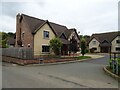
2
Executive homes at Yell Bank, Montford Bridge
Large, detached, four-bedroom or more homes in an 'executive ghetto' here.
I don't envy the affluent their so called luxuries: their homes on steroids, their extra interior space, their sterile, characterless, cheerless nightly crash-pads in between breakfast meetings, zoom/teams meetings, overnight stays in chain hotels and expense claims self-admin splurges.
Poor benighted savages.
Affordable homes, that's what this nation needs. No ghettos!
Image: © Jeremy Bolwell
Taken: 22 Mar 2023
0.03 miles
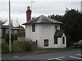
3
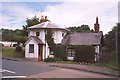
Old Toll House, Montford Bridge
Montford Bridge was rebuilt by Thomas Telford in 1792 as part of the improvements to the London to Holyhead road, which became the A5.
Image: © Humphrey Bolton
Taken: 21 Jun 2000
0.03 miles
4
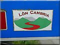
Lon Cambria cycleway sign at Montford Bridge
This is apparently a cycle route linking Shrewsbury with Aberystwyth, https://cycle.travel/route/lon_cambria here.
Image: © Jeremy Bolwell
Taken: 22 Mar 2023
0.04 miles
6
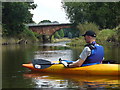
Montford Road Bridge - From the River
Image: © Anthony Parkes
Taken: 5 Aug 2007
0.05 miles
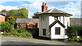
8
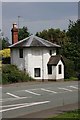
Old Toll House, Montford Bridge
On the former A5.
Image: © JThomas
Taken: 4 Sep 2024
0.05 miles
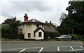
9
Old Toll House by Holyhead Road, Montford Bridge
Toll House in the parish of Montford, The Round House, No. 1, Holyhead Road, SY4 1ED.
Grade II listed.
List Entry Number: 1175719 https://historicengland.org.uk/listing/the-list/list-entry/1175719
To be surveyed
Milestone Society National ID: SA.MON
Image: © Milestone Society
Taken: Unknown
0.05 miles
10
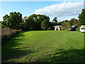
Camping field near the Wingfield Arms
The main site is just south of the pub, but this field gets used as a campsite on occasions too, as the nearby pub's attractions are handy.
Image: © Richard Law
Taken: 19 Sep 2017
0.05 miles