IMAGES TAKEN NEAR TO
Holyhead Road, SHREWSBURY, SY4 1AY
Introduction
This page details the photographs taken nearby to Holyhead Road, SY4 1AY by members of the Geograph project.
The Geograph project started in 2005 with the aim of publishing, organising and preserving representative images for every square kilometre of Great Britain, Ireland and the Isle of Man.

There are currently over 7.5m images from over14,400 individuals and you can help contribute to the project by visiting https://www.geograph.org.uk
Image Map
Images are licensed for reuse under creativecommons.org/licenses/by-sa/2.0
Notes
- Clicking on the map will re-center to the selected point.
- The higher the marker number, the further away the image location is from the centre of the postcode.
Image Listing (11 Images Found)
Images are licensed for reuse under creativecommons.org/licenses/by-sa/2.0
Image
Details
Distance
1
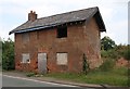
Old Toll House, Wolfshead
Toll House in the parish of Great Ness, on the old A5, The Gatehouse, near Wolfshead.
Grade II listed.
List Entry Number: 1390984 https://historicengland.org.uk/listing/the-list/list-entry/1390984
To be surveyed
Milestone Society National ID: SA.GRE
Image: © Milestone Society
Taken: Unknown
0.00 miles
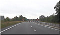
4
Old Milestone
Old milestone on what would have been the A.5 near to Kinton, Shropshire. For overall view see http://www.geograph.org.uk/photo/4776159
Image: © Keith Evans
Taken: 17 Oct 2015
0.06 miles
5

Holyhead 97
Old milestone to the left in hedge on what would have been the A.5 near to Kinton, Shropshire. For close up view see http://www.geograph.org.uk/photo/4776156
Image: © Keith Evans
Taken: 17 Oct 2015
0.08 miles
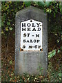
6
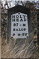
Old Milestone by the former A5, Heath Farm, Great Ness parish
Metal plate attached to stone post by the UC road (was A5), in parish of GREAT NESS (SHREWSBURY AND ATCHAM District), 90m East of Wolfshead Farmhouse, on the verge (beside hedge separating road from the new A5), on West side of road. Telford gabled iron plate, erected by the Holyhead Road turnpike trust in the 19th century.
Inscription reads:-
HOLY-
HEAD
97 - M
SALOP
9 M-6F
Grade II listed.
List Entry Number: 1055141 https://historicengland.org.uk/listing/the-list/list-entry/1055141
Milestone Society National ID: SA_HH097.
Image: © A Reade/J Higgins
Taken: 8 Jul 2008
0.09 miles
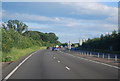
8
Approaching north end of Nesscliffe bypass
Image: © John Firth
Taken: 14 Oct 2013
0.12 miles
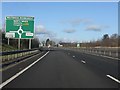
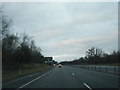
10
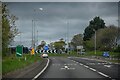
Great Ness : A5
Approaching Wolfshead Roundabout.
Image: © Lewis Clarke
Taken: 19 Apr 2024
0.17 miles