IMAGES TAKEN NEAR TO
Copthorne Rise, SHREWSBURY, SY3 8NT
Introduction
This page details the photographs taken nearby to Copthorne Rise, SY3 8NT by members of the Geograph project.
The Geograph project started in 2005 with the aim of publishing, organising and preserving representative images for every square kilometre of Great Britain, Ireland and the Isle of Man.

There are currently over 7.5m images from over14,400 individuals and you can help contribute to the project by visiting https://www.geograph.org.uk
Image Map
Images are licensed for reuse under creativecommons.org/licenses/by-sa/2.0
Notes
- Clicking on the map will re-center to the selected point.
- The higher the marker number, the further away the image location is from the centre of the postcode.
Image Listing (297 Images Found)
Images are licensed for reuse under creativecommons.org/licenses/by-sa/2.0
Image
Details
Distance
1
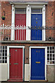
Doors on New Street
An unusual arrangement of upper and lower doors - part of Providence Terrace on New Street in the Frankwell district of Shrewsbury. Note the ornate railings on the upper storey.
Image: © Stephen McKay
Taken: 7 Mar 2009
0.05 miles
2
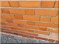
Ordnance Survey Cut Mark
This OS cut mark can be found on No63 Copthorne Road. It marks a point 70.026m above mean sea level.
Image: © Adrian Dust
Taken: 3 Jul 2023
0.06 miles
3
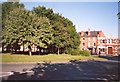
Park on the roundabout, Frankwell, Shrewsbury
Frankwell is a medieval suburb of Shrewsbury - ribbon development along the narrow old road over the Welsh Bridge. At the end is a little park in the middle of a road junction.
Image: © Humphrey Bolton
Taken: 18 Jun 2000
0.07 miles
4
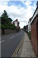
New Street
Looking along New Street near Water Lane.
Image: © DS Pugh
Taken: 29 Jul 2018
0.08 miles
5
Gardens behind New Street, Shrewsbury
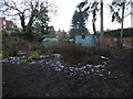
An intriguing plot with chickens, veg gardens and sheds, and I think an old caravan.
Image: © Jeremy Bolwell
Taken: 30 Dec 2020
0.08 miles
7
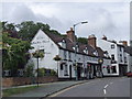
The Olde Buck's Head Inn, Shrewsbury
Quite an extensive range of buildings now comprise the pub. Courtyard at rear. Award winning beer garden too apparently.
Image: © Jeremy Bolwell
Taken: 26 Sep 2011
0.09 miles
8
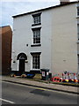
53 New Street, Shrewsbury
The lefthand end of a terrace of 5 similar houses, which were all built around the 1840s, and which were collectively Grade II listed https://britishlistedbuildings.co.uk/101254696-53-57-new-street-shrewsbury#.XJfWzyj7TIU in 1972.
Image: © Richard Law
Taken: 23 Mar 2019
0.10 miles
9
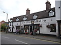
The Olde Buck's Head Inn, Shrewsbury
One of Shrewsbury's many good pubs. I stayed here once, just over a decade ago, and was struck back then what a good 'proper pub' it was. Still is.
Image: © Jeremy Bolwell
Taken: 26 Sep 2011
0.10 miles
10
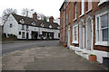
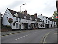
Frankwell, Shrewsbury
Frankwell is both the name of this street and the surrounding district, immediately across the Welsh Bridge from Shrewsbury town centre. The area was first developed in Norman times and by the 17th century had become a centre for free trades - lying outside the jurisdiction of the Lord of Shrewsbury Castle. It is nowadays a more mundane suburb, but there still remain sufficient buildings of interest to justify its status as a conservation area.
Image: © Stephen McKay
Taken: 7 Mar 2009
0.10 miles