IMAGES TAKEN NEAR TO
Llanddewi Brefi, TREGARON, SY25 6PA
Introduction
This page details the photographs taken nearby to SY25 6PA by members of the Geograph project.
The Geograph project started in 2005 with the aim of publishing, organising and preserving representative images for every square kilometre of Great Britain, Ireland and the Isle of Man.

There are currently over 7.5m images from over14,400 individuals and you can help contribute to the project by visiting https://www.geograph.org.uk
Image Map
Images are licensed for reuse under creativecommons.org/licenses/by-sa/2.0
Notes
- Clicking on the map will re-center to the selected point.
- The higher the marker number, the further away the image location is from the centre of the postcode.
Image Listing (16 Images Found)
Images are licensed for reuse under creativecommons.org/licenses/by-sa/2.0
Image
Details
Distance
1
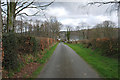
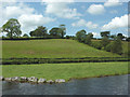
Lane near Pont Gogoyan
Running mainly east from Olmarch towards the Afon Teifi.
Image: © Nigel Brown
Taken: 5 Apr 2008
0.03 miles
2
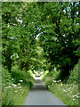
Lane to Olmarch from Pont Gogoyan, Ceredigion
This is the single track lane climbing out of the Teifi valley.
Image: © Roger D Kidd
Taken: 20 Jul 2011
0.16 miles
3
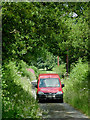
Postal delivery near Pont Gogoyan, Ceredigion
I saw this "postie" an hour or so ago by Blaendoethie (SN73905410), and have seen him several times since as he works his very rural round, based in Tregaron. Here he descends the lane from Olmarch to Pont Gogoyan in the Teifi valley.
Image: © Roger D Kidd
Taken: 20 Jul 2011
0.16 miles
4
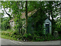
Former schoolroom near Pont Gogoyan, Ceredigion
This partly overgrown corrugated galvanised iron-clad building of chapel-like appearance is on the corner of the narrow lane to Olmarch.
It is the former Calvinist Gogoyan schoolroom. http://www.dyfedfhs.org.uk/register/sac9.htm
Image: © Roger D Kidd
Taken: 20 Jul 2011
0.20 miles
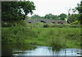
5
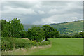
Farmland south-east of Olmarch
The lane is descending from Olmarch to the bridge crossing of the Afon Teifi at Pont Gogoyan
Image: © Roger D Kidd
Taken: 20 Jul 2011
0.20 miles
6
Afon Teifi and hillside west of Pont Gogoyan, Ceredigion
Seen from the middle of the bridge, the river flows from right to left. The water level is above normal because of the three rainy days preceding the day of the image. Behind the hedge is the lane to Cockshead (right) and Llanfair Clydogau (left).
Image: © Roger D Kidd
Taken: 20 Jul 2011
0.21 miles
7
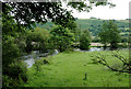
Pasture by the Afon Teifi south of Pont Gogoyan, Ceredigion
This shows the flood plain where the river meanders south-west of Llanddewi-Brefi.
The river is flowing swiftly to the right, following a long wet weekend.
The Teifi has its source in Llyn Teifi about twelve miles to the north-east, one of several lakes known collectively as the Teifi Pools. It forms the boundary between the counties of Ceredigion and Carmarthenshire for much of its 75 mile length, flowing into the sea below the town of Aberteifi (Cardigan).
Image: © Roger D Kidd
Taken: 20 Jul 2011
0.22 miles
8
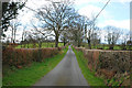
Lane heading west from near Pont Gogoyan
Heading towards Olmarch on the A485.
Image: © Nigel Brown
Taken: 5 Apr 2008
0.22 miles
9
Pasture by the Afon Teifi south of Pont Gogoyan, Ceredigion
This is the scene using telephoto assistance looking across the tight meandering River Teifi. The river is flowing swiftly (towards the camera) following three wet and windy days.
The bridge crosses the Afon Teifi just over a mile (2 km) from Llanddewi-Brefi. This structure is Grade II* listed, and was built late in the eighteenth century. It is a humped bridge of five rounded arches, about forty metres long and only two and a half metres in width. The river flows from left to right.
Image: © Roger D Kidd
Taken: 20 Jul 2011
0.22 miles
10
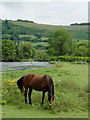
Grazing by the Afon Teifi at Pont Gogoyan, Ceredigion
The river was flowing swiftly here after three days of rain. Several friendly horses were grazing.
Image: © Roger D Kidd
Taken: 20 Jul 2011
0.23 miles