IMAGES TAKEN NEAR TO
TALYBONT, SY24 5EA
Introduction
This page details the photographs taken nearby to SY24 5EA by members of the Geograph project.
The Geograph project started in 2005 with the aim of publishing, organising and preserving representative images for every square kilometre of Great Britain, Ireland and the Isle of Man.

There are currently over 7.5m images from over14,400 individuals and you can help contribute to the project by visiting https://www.geograph.org.uk
Image Map
Images are licensed for reuse under creativecommons.org/licenses/by-sa/2.0
Notes
- Clicking on the map will re-center to the selected point.
- The higher the marker number, the further away the image location is from the centre of the postcode.
Image Listing (50 Images Found)
Images are licensed for reuse under creativecommons.org/licenses/by-sa/2.0
Image
Details
Distance
1
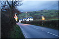
The A487 entering Talybont
Viewed on a wet evening.
Image: © Bill Boaden
Taken: 14 Jan 2013
0.01 miles
2
The A487 on the southern side of Tal-y-Bont
Image: © Eirian Evans
Taken: 28 May 2021
0.03 miles
3
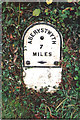
Old Milestone south west of Pont Tal-y-bont, Ceredigion
Aberystwyth plate by the A487, in parish of Ceulanamaesmawr (Ceredigion District), South of Talybont some 350m South of Talybont Square, in bank, North side of road.
Inscription reads:-
ABERYSTWYTH
7
MILES
Grade II listed by Cadw.
Reference Number 18897: https://cadwpublic-api.azurewebsites.net/reports/listedbuilding/FullReport?lang=&id=18897
Surveyed
Milestone Society National ID: CRD_AYMC07
Image: © Milestone Society
Taken: Unknown
0.05 miles
4
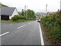
Lane off the A487
Just south of Talybont, this lane leaves the A487 to service small communities to the east of the main road. Viewed on a wet evening.
Image: © Bill Boaden
Taken: 14 Jan 2013
0.07 miles
5
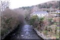
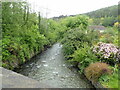
Looking down the Leri
The view west, downstream from the bridge in the centre of Tal-y-bont.
Image: © Chris Denny
Taken: 20 Feb 2011
0.07 miles
6
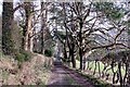
Into Tal-y-bont
An avenue of stately conifers leads into Tal-y-bont from the forestry plantations to the west of the village.
Image: © Chris Denny
Taken: 20 Feb 2011
0.10 miles
7
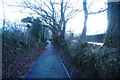
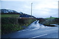
Path by the A487
Immediately out of Talybont there is no provision for pedestrians and it is dangerous. However on this country stretch, this excellent path has been provided.
Image: © Bill Boaden
Taken: 14 Jan 2013
0.10 miles
8
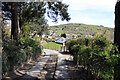
On the Devil's Bridge to Borth trail
Looking back over Tal-y-bont.
Image: © John Lucas
Taken: 23 Apr 2021
0.11 miles
9
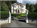
A house in Tal-y-bont
This rather fine house is passed on the Borth to Devil's Bridge path.
Image: © David Purchase
Taken: 18 Sep 2010
0.12 miles
10
Afon Leri River
Heading towards the Dovey estuary at Traeth Maelgwyn
Image: © Eirian Evans
Taken: 28 May 2021
0.12 miles