IMAGES TAKEN NEAR TO
Llandre, BOW STREET, SY24 5AB
Introduction
This page details the photographs taken nearby to SY24 5AB by members of the Geograph project.
The Geograph project started in 2005 with the aim of publishing, organising and preserving representative images for every square kilometre of Great Britain, Ireland and the Isle of Man.

There are currently over 7.5m images from over14,400 individuals and you can help contribute to the project by visiting https://www.geograph.org.uk
Image Map
Images are licensed for reuse under creativecommons.org/licenses/by-sa/2.0
Notes
- Clicking on the map will re-center to the selected point.
- The higher the marker number, the further away the image location is from the centre of the postcode.
Image Listing (18 Images Found)
Images are licensed for reuse under creativecommons.org/licenses/by-sa/2.0
Image
Details
Distance
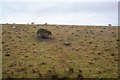
1
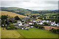
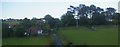
A view over Llandre
The old school building is visible in the centre of the view. It closed in the 1990s and later became a soft play centre. That subsequently closed in 2016 after a couple of years of operation. The building was being offered for sale in 2017 for £230,000. It is featured on the Waymarking website: https://www.waymarking.com/waymarks/WMAZRK_Old_Llandre_School_Llandre_Bow_Street_Ceredigion_Wales_UK
Image: © John Lucas
Taken: 5 Jul 2022
0.04 miles
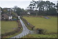
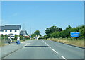
4
Llandre / Llanfihangel-genau'r-gwyn: houses at the south end of the village, from the railway
Presumably, in the fullness of time, the field on the right will be developed for housing: the short stub of road coming down from the main road into the field suggests that will be its ultimate fate.
Image: © Christopher Hilton
Taken: 8 Jun 2015
0.14 miles