IMAGES TAKEN NEAR TO
Glanfedw, ABERYSTWYTH, SY23 4RE
Introduction
This page details the photographs taken nearby to Glanfedw, SY23 4RE by members of the Geograph project.
The Geograph project started in 2005 with the aim of publishing, organising and preserving representative images for every square kilometre of Great Britain, Ireland and the Isle of Man.

There are currently over 7.5m images from over14,400 individuals and you can help contribute to the project by visiting https://www.geograph.org.uk
Image Map
Images are licensed for reuse under creativecommons.org/licenses/by-sa/2.0
Notes
- Clicking on the map will re-center to the selected point.
- The higher the marker number, the further away the image location is from the centre of the postcode.
Image Listing (10 Images Found)
Images are licensed for reuse under creativecommons.org/licenses/by-sa/2.0
Image
Details
Distance
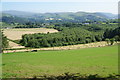
1
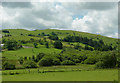
The slopes of Pen Felin-wynt , Ceredigion
The summit (out of sight) of Pen Felin-wynt is at 372 metres (1220 feet).
Image: © Roger D Kidd
Taken: 23 Jul 2011
0.12 miles
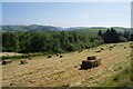
3
Muck-spreader in a fallow field near Tan-y-graig
The hillside ahead slopes towards the Mynach valley.
Image: © Bill Boaden
Taken: 11 Jul 2013
0.13 miles
4

Field near Tan-y-graig
A newly sown crop is growing up. Without livestock I suppose there is no reason to keep the gate closed.
Image: © Bill Boaden
Taken: 11 Jul 2013
0.14 miles
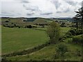
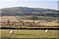
5
Making hay while the sun shines
Quiet farmland south of Devil's Bridge.
Image: © Bill Boaden
Taken: 11 Jul 2013
0.16 miles
6
Hillside above Devil's Bridge
Looking over farmland and woodland to the point where the Rheidol and Mynach rivers meet.
Image: © Bill Boaden
Taken: 11 Jul 2013
0.16 miles
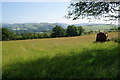
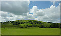
7
Drained field on Rhos y Gell
The field in the middle distance has been reclaimed from more boggy areas by building substantial drainage ditches.
Image: © Nigel Brown
Taken: 30 Dec 2008
0.18 miles
8
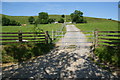
Track to Pant-gl
This route is not open to the public.
Image: © Bill Boaden
Taken: 11 Jul 2013
0.18 miles
9
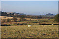
Farmland south of Devil's Bridge, Ceredigion
The summit beyond farms at Glanfedw and Tan-y-graig is Pen Felin-wynt (372 metres; 1220 feet).
Image: © Roger D Kidd
Taken: 23 Jul 2011
0.23 miles
10
Rhos y Gell
Looking towards the northern end of the moor, and the watershed between the Rheidol and Ystwyth catchment areas. Rhos y Gell in English is Moor of the Cell; the origins of the name are a bit puzzling. The area in view is also known as Gors Lwyd, the Grey-brown Bog, which seen on a less sparkling day than this one is more understandable.
Image: © Nigel Brown
Taken: 30 Dec 2008
0.23 miles