IMAGES TAKEN NEAR TO
Blaenplwyf, ABERYSTWYTH, SY23 4DG
Introduction
This page details the photographs taken nearby to SY23 4DG by members of the Geograph project.
The Geograph project started in 2005 with the aim of publishing, organising and preserving representative images for every square kilometre of Great Britain, Ireland and the Isle of Man.

There are currently over 7.5m images from over14,400 individuals and you can help contribute to the project by visiting https://www.geograph.org.uk
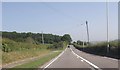
Image Map
Images are licensed for reuse under creativecommons.org/licenses/by-sa/2.0
Notes
- Clicking on the map will re-center to the selected point.
- The higher the marker number, the further away the image location is from the centre of the postcode.
Image Listing (7 Images Found)
Images are licensed for reuse under creativecommons.org/licenses/by-sa/2.0
Image
Details
Distance
2
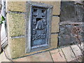
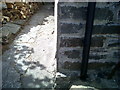
Ordnance Survey Flush Bracket S8281
This can be found on the wall of the former Mission Rooms (now private house).
For more detail see : http://www.bench-marks.org.uk/bm15301
Image: © Peter Wood
Taken: 18 May 2013
0.06 miles
3
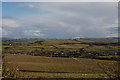
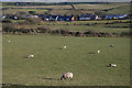
Farmland around Blaenplwyf
Typical of the good farmland for which rural south Ceredigion is noted.
Image: © Nigel Brown
Taken: 16 Feb 2010
0.13 miles
4
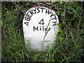
Chancery, Milestone - Aberystwyth 4
The milestone used to bear an Ordnance Survey benchmark, which was used on the Warrington to Pembroke Docks line of the First Primary Levelling of England & Wales in 1851-1852. The mark has been erased. Description: 623. Mark on the 4th milestone from Aberystwyth ; 2.46 ft. above surface. Page 533 of the abstract: http://www.trigtools.co.uk/data/1GL/1GLA_533.png
Image: © N Scott
Taken: 22 Jun 2015
0.16 miles
5
Ordnance Survey Benchmark - Blaenplwyf, The Park
Ordnance Survey Benchmark (OSBM) used for levelling height above Ordnance Datum (OD).
It has not been used as a benchmark by the OS for many years.
Image: © N Scott
Taken: 22 Jun 2015
0.19 miles
6
Fields west of Blaenplwyf
Grazing land, with the southern part of the village beyond.
Image: © Nigel Brown
Taken: 16 Feb 2010
0.22 miles
7
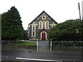
Chapel at Blaenplwyf beside the main road
Dated 16th August 1878. Its hey day must have been before the Great War and its decline gradual since and now a headlong rush to low attendance now I assume.
Image: © Jeremy Bolwell
Taken: 3 Mar 2019
0.23 miles