IMAGES TAKEN NEAR TO
Maesmagwr, ABERYSTWYTH, SY23 4AS
Introduction
This page details the photographs taken nearby to Maesmagwr, SY23 4AS by members of the Geograph project.
The Geograph project started in 2005 with the aim of publishing, organising and preserving representative images for every square kilometre of Great Britain, Ireland and the Isle of Man.

There are currently over 7.5m images from over14,400 individuals and you can help contribute to the project by visiting https://www.geograph.org.uk
Image Map
Images are licensed for reuse under creativecommons.org/licenses/by-sa/2.0
Notes
- Clicking on the map will re-center to the selected point.
- The higher the marker number, the further away the image location is from the centre of the postcode.
Image Listing (9 Images Found)
Images are licensed for reuse under creativecommons.org/licenses/by-sa/2.0
Image
Details
Distance
1
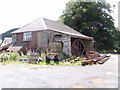
The old sawmill Abermagwr
This is the old water powered sawmill. Sadly no longer used as the water from the mill leet was diverted after a flood many years ago. Used now as storage by the current owner and blacksmith.
Image: © David Gilmour
Taken: 12 Aug 2007
0.01 miles
2
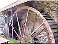
Close up of wheel
Picture of the waterwheel on the old sawmill in Abermagwr.
Image: © David Gilmour
Taken: 12 Aug 2007
0.03 miles
3
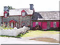
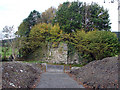
Yr Hen Efail
This is the Yr Hen Efail ( The Old Smithy ) in Abermagwr. Behind to the left is the old water powered sawmill.
Image: © David Gilmour
Taken: 12 Aug 2007
0.07 miles
4
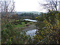
Afon Ystwyth
Viewed from the new Ystwyth Trail cycle route.
Image: © John Lucas
Taken: 27 Nov 2006
0.12 miles
5
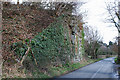
Remains of railway bridge near Trawscoed
Once carrying the railway from Aberystwyth to Carmarthen, of which this section started out as the Strata Florida to Aberystwyth branch of the Manchester & Milford railway; as the main line north from Strata Florida station was never built, in practice it became the main line. The bridge was quite high, the railway being carried on a high embankment at this point to ease the gradient between here and Tynygraig to the south.
Image: © Nigel Brown
Taken: 26 Mar 2010
0.23 miles
6
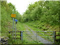
Disused Railway Bridge on the B4575 road.
This bridge once carried the Carmarthen to Aberystwyth railway line. The abutment on the left is intact but that on the right has been demolished to provide access to the new Ystwyth Trail (Tregaron to Aberystwyth) cycle route.
Image: © John Lucas
Taken: 2 Oct 2006
0.23 miles
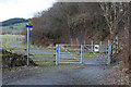
7
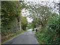
Ystwyth Trail near Crosswood
The Ystwyth Trail is a 32.1km/20M footpath and cycle route linking Tregaron and Aberystwyth. Part of the trail follows the track of the old Great Western Railway line. Here is where it crosses the B4575.
Image: © Eirian Evans
Taken: 22 May 2015
0.24 miles
8
Ystwyth Cycle Trail
This is the site of a railway bridge that has been partially demolished to provide access for the cycle trail onto the old railway trackbed. The abutment opposite is still intact.
Image: © John Lucas
Taken: 2 Oct 2006
0.24 miles
9
The Ystwyth Trail near Trawscoed
For much of its length, this trail between Aberystwyth and Tregaron uses the trackbed of the old railway line connecting the two towns. At this point the railway bridge over the B4575 no longer exists, so the trail descends to the road and regains the trackbed on the other side.
Image: © Nigel Brown
Taken: 26 Mar 2010
0.24 miles