IMAGES TAKEN NEAR TO
Penrhyncoch, ABERYSTWYTH, SY23 3EE
Introduction
This page details the photographs taken nearby to SY23 3EE by members of the Geograph project.
The Geograph project started in 2005 with the aim of publishing, organising and preserving representative images for every square kilometre of Great Britain, Ireland and the Isle of Man.

There are currently over 7.5m images from over14,400 individuals and you can help contribute to the project by visiting https://www.geograph.org.uk
Image Map
Images are licensed for reuse under creativecommons.org/licenses/by-sa/2.0
Notes
- Clicking on the map will re-center to the selected point.
- The higher the marker number, the further away the image location is from the centre of the postcode.
Image Listing (8 Images Found)
Images are licensed for reuse under creativecommons.org/licenses/by-sa/2.0
Image
Details
Distance
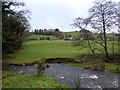
2
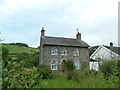
Western approach to Penrhyncoch
As the village has become more bloated over the years, so have its boundaries expanded outwards; the boundary used to be a considerably further east.
Image: © Nigel Brown
Taken: 7 May 2009
0.02 miles
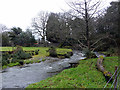
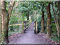
4
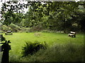
Picnic area near Gogerddan
Picnic area adjacent to recreational forest trail established through Forest Enterprise woodland.
Image: © Nigel Callaghan
Taken: 2 Jul 2005
0.06 miles
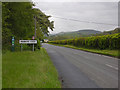
8
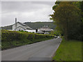
Minor road passing the Welsh Plant Breeding Station
The road is the main access to the village of Penrhyncoch. The Welsh Plant Breeding Station is still referred to by that name locally (WPBS for short, or even PBS), although officially it has had other, less memorable, titles, in recent years. It is now part of Aberystwyth University.
Image: © Nigel Brown
Taken: 7 May 2009
0.23 miles