IMAGES TAKEN NEAR TO
Middletown, WELSHPOOL, SY21 8EW
Introduction
This page details the photographs taken nearby to SY21 8EW by members of the Geograph project.
The Geograph project started in 2005 with the aim of publishing, organising and preserving representative images for every square kilometre of Great Britain, Ireland and the Isle of Man.

There are currently over 7.5m images from over14,400 individuals and you can help contribute to the project by visiting https://www.geograph.org.uk
Image Map
Images are licensed for reuse under creativecommons.org/licenses/by-sa/2.0
Notes
- Clicking on the map will re-center to the selected point.
- The higher the marker number, the further away the image location is from the centre of the postcode.
Image Listing (6 Images Found)
Images are licensed for reuse under creativecommons.org/licenses/by-sa/2.0
Image
Details
Distance
1
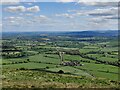
Shropshire viewed from Middletown Hill
Middletown Hill is part of the Breidden Hills, which are made up of Breidden Hill (365m 1,197ft), Moel y Golfa (meaning Bare or Bald Hill), the highest at (403m 1,322ft), Middletown Hill (367m 1,204ft), Kempsters Hill and Bausely Hill. They are on the border of England and Wales (Shropshire/Powys), about ten miles west of Shrewsbury.
Breidden Hill is an extinct volcano, and has Rodney's Pillar on its summit. Middletown Hill has an ancient Iron Age Hill fort on its summit.
Image: © Mat Fascione
Taken: 7 May 2022
0.03 miles
4
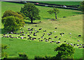
Odd Man (or Women) Out?
So can you see the odd man out?!
Image: © Rod Trevaskus
Taken: 10 May 2009
0.13 miles
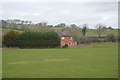
6

Plas-y-Court railway Halt (site), Shropshire
Opened in 1934 jointly by the Great Western Railway and London Midland & Scottish Railway on the line from Shrewsbury to Welshpool, this halt closed in 1960.
View west towards Breidden and Welshpool. The diminutive single, timber platform had been to the left of the track. The railway line had opened in 1862 so this halt was a late addition.
Image: © Nigel Thompson
Taken: 10 Dec 2021
0.22 miles