IMAGES TAKEN NEAR TO
Foundry Court, WELSHPOOL, SY21 7TT
Introduction
This page details the photographs taken nearby to Foundry Court, SY21 7TT by members of the Geograph project.
The Geograph project started in 2005 with the aim of publishing, organising and preserving representative images for every square kilometre of Great Britain, Ireland and the Isle of Man.

There are currently over 7.5m images from over14,400 individuals and you can help contribute to the project by visiting https://www.geograph.org.uk
Image Map
Images are licensed for reuse under creativecommons.org/licenses/by-sa/2.0
Notes
- Clicking on the map will re-center to the selected point.
- The higher the marker number, the further away the image location is from the centre of the postcode.
Image Listing (217 Images Found)
Images are licensed for reuse under creativecommons.org/licenses/by-sa/2.0
Image
Details
Distance
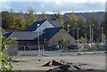
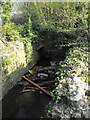
1
Weir on Lledan Brook
The brook takes a strange course through the town. It emerges from under the livestock market about 175m upstream from here. Just below this weir it turns through about 100 degrees, runs SE for about 40m (under this footbridge http://www.geograph.org.uk/photo/2192788 ) then curves round and under the site of the Mill Lane foundry (now the Welsh Sausage Factory).
Image: © Penny Mayes
Taken: 12 Apr 2010
0.03 miles
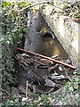
2
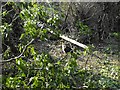
Beside Lledan Brook
According to the 19th century maps (on http://www.old-maps.co.uk/maps.html?txtXCoord=323000&txtYCoord=307500 ) Foundry Lane used to run down this side of the brook, or perhaps this was the entrance roadway. It looks as if someone has been trying to clear the area recently but they haven't made much head-way. The cat seemed pleased to see me.
Image: © Penny Mayes
Taken: 12 Apr 2010
0.04 miles
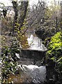
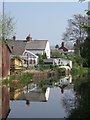
4
Footbridge over Lledan Brook
A brick footbridge crosses the brook (but goes nowhere) next to Foundry Lane (out of shot left). Looking at 19th century maps I think the lane used to run down the right-hand side of the brook here so the footbridge gave access to buildings associated with the old Mill Lane Foundry.
Image: © Penny Mayes
Taken: 12 Apr 2010
0.05 miles
5
Looking down Lledan Brook
From the footbridge http://www.geograph.org.uk/photo/2192788.
Image: © Penny Mayes
Taken: 12 Apr 2010
0.05 miles
7
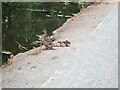
Mum standing guard
Mallard and three ducklings, Montgomery Canal
Image: © Eirian Evans
Taken: 3 Aug 2021
0.06 miles
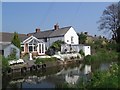
8
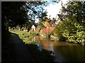
Colours on Montgomery Canal
At bend of canal near Mill Lane bridge
Image: © John Firth
Taken: 16 Oct 2012
0.06 miles
9
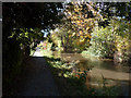
Autumn along the canal
Montgomery Canal at the rear of Salop Road
Image: © John Firth
Taken: 16 Oct 2012
0.07 miles