IMAGES TAKEN NEAR TO
Llangyniew, WELSHPOOL, SY21 0JT
Introduction
This page details the photographs taken nearby to SY21 0JT by members of the Geograph project.
The Geograph project started in 2005 with the aim of publishing, organising and preserving representative images for every square kilometre of Great Britain, Ireland and the Isle of Man.

There are currently over 7.5m images from over14,400 individuals and you can help contribute to the project by visiting https://www.geograph.org.uk
Image Map
Images are licensed for reuse under creativecommons.org/licenses/by-sa/2.0
Notes
- Clicking on the map will re-center to the selected point.
- The higher the marker number, the further away the image location is from the centre of the postcode.
Image Listing (10 Images Found)
Images are licensed for reuse under creativecommons.org/licenses/by-sa/2.0
Image
Details
Distance
1
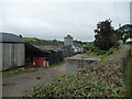
Part of Cefnllwyd farm
A well kept farm house and yard.
Image: © Jeremy Bolwell
Taken: 30 Sep 2012
0.01 miles
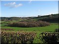
2
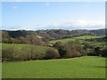
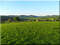
Rolling Hills
Seen from the B4389 close to Cefnllwyd.
Image: © Roger Gilbertson
Taken: 10 Jan 2007
0.10 miles
4
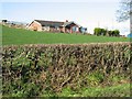
New Build
A bungalow built on former pasture at Cefnllwyd.
Image: © Roger Gilbertson
Taken: 10 Jan 2007
0.10 miles
5
The View To The East
From the B4389 close to Pentre.
Image: © Roger Gilbertson
Taken: 10 Jan 2007
0.15 miles
6
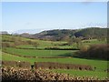
Below The Fort
At one time a fort commanded the area in the photograph looking down a side valley leading to the Afon / River Banwy.
Image: © Roger Gilbertson
Taken: 10 Jan 2007
0.15 miles
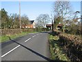
7
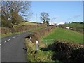
The Road To Oswestry
The B4389 close to Pentre.
Image: © Roger Gilbertson
Taken: 10 Jan 2007
0.15 miles
8
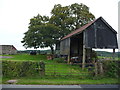
Old corrugated barn beside the road
One of those old barns that has a load of stuff stored in it but even at a glance you can tell that most, if not all, of it has limited potential as a resource for future redeployment, recycling or re-use.
What is the name of that 'law' that states that whatever available space you have you will fill it?
Image: © Jeremy Bolwell
Taken: 30 Sep 2012
0.16 miles
9

Up the hill towards Meifod
The B4389 at the junction of the minor road to Dolanog
Image: © John Firth
Taken: 24 Oct 2010
0.20 miles
10
Pentre Camp Hill Fort, Llangyniew
Pentre Camp, aka Pen-y-Castell aka Pen-y-Gorddin. From nearby this looks like just another grassy dome. You have to get into the air to appreciate that once there was a settlement here, and that's how I first spotted it - flying over my own house not 500 metres away. This photo taken from the top, looking down the Vynrwy valley towards Meifod on a glorious late spring evening.
For further info on this any many other sites of antiquity in the area please visit http://www.coflein.gov.uk
Image: © Martin Evans
Taken: 26 May 2012
0.22 miles