IMAGES TAKEN NEAR TO
Aberhosan, MACHYNLLETH, SY20 8SQ
Introduction
This page details the photographs taken nearby to SY20 8SQ by members of the Geograph project.
The Geograph project started in 2005 with the aim of publishing, organising and preserving representative images for every square kilometre of Great Britain, Ireland and the Isle of Man.

There are currently over 7.5m images from over14,400 individuals and you can help contribute to the project by visiting https://www.geograph.org.uk
Image Map
Images are licensed for reuse under creativecommons.org/licenses/by-sa/2.0
Notes
- Clicking on the map will re-center to the selected point.
- The higher the marker number, the further away the image location is from the centre of the postcode.
Image Listing (4 Images Found)
Images are licensed for reuse under creativecommons.org/licenses/by-sa/2.0
Image
Details
Distance
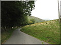
1
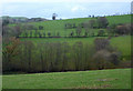
Nant y Gwennill
Green pastures either side of the stream, seen from the mountain lane between Machynlleth and Staylittle.
Image: © Andrew Hill
Taken: 20 Nov 2009
0.12 miles
3
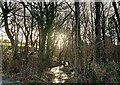
Nant-y-Gwenill
Winter morning sunlight catches the tiny stream of Nant-y-Gwenill. The map shows a footpath running along its bank through the wood, though there is no evidence of that on the ground.
Image: © Mike Parker
Taken: 11 Feb 2022
0.18 miles