IMAGES TAKEN NEAR TO
Clos Yr Hen Ysgol, SY18 6DG
Introduction
This page details the photographs taken nearby to Clos Yr Hen Ysgol, SY18 6DG by members of the Geograph project.
The Geograph project started in 2005 with the aim of publishing, organising and preserving representative images for every square kilometre of Great Britain, Ireland and the Isle of Man.

There are currently over 7.5m images from over14,400 individuals and you can help contribute to the project by visiting https://www.geograph.org.uk
Image Map
Images are licensed for reuse under creativecommons.org/licenses/by-sa/2.0
Notes
- Clicking on the map will re-center to the selected point.
- The higher the marker number, the further away the image location is from the centre of the postcode.
Image Listing (180 Images Found)
Images are licensed for reuse under creativecommons.org/licenses/by-sa/2.0
Image
Details
Distance
1
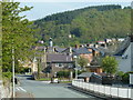
Gorn Road into Llanidloes
View from by the bridge over the A470 to the town and the wooded hillside beyond.
Image: © Andrew Hill
Taken: 23 May 2012
0.04 miles
3
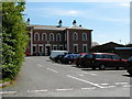
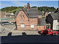
Station Building, Llanidloes
This imposing building was built as a combined station and HQ for the Cambrian Railway. The railway through Llanidloes closed in 1962 and the restored building is now in use as small business offices.
Image: © John Lucas
Taken: 24 May 2001
0.05 miles
4
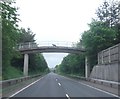
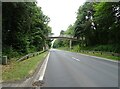
Footbridge over the A470 to the centre of Llanidloes
A useful cut through for residents east of the main road.
Image: © Andrew Hill
Taken: 23 May 2012
0.05 miles
6

The former railway station, Llanidloes
A grand station building for a provincial small town but a gem.
Image: © Jeremy Bolwell
Taken: 17 Aug 2012
0.05 miles
7
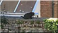
Cat at Llanidloes
This black cat was resting on top of the wall by the houses on the High Street.
Image: © Fabian Musto
Taken: 5 Jun 2021
0.06 miles
8
Houses at Llanidloes
The brick building to the left was built in the 18th or 19th century, and has an identical look to the former railway station. It is situated south at the end of the Google Maps view of Cemetery Square, and I found out it does not have listed status.
Image: © Fabian Musto
Taken: 5 Jun 2021
0.06 miles
9
Magistrate's Court (Llanidloes)
Built in 1864 as the police station, this High Victorian Gothic building shows influences of the work of Prichard and Seddon. This building now houses a private residence.
Image: © Fabian Musto
Taken: 5 Jun 2021
0.07 miles
10
No. 40-42 High Street (Llanidloes)
Built as a group of single-storey cottages around 1646, they were enlarged in the mid 18th century and were refronted around 1800. These were grade II listed in April 1989.
Image: © Fabian Musto
Taken: 5 Jun 2021
0.07 miles