IMAGES TAKEN NEAR TO
Lon Derw, NEWTOWN, SY16 1QN
Introduction
This page details the photographs taken nearby to Lon Derw, SY16 1QN by members of the Geograph project.
The Geograph project started in 2005 with the aim of publishing, organising and preserving representative images for every square kilometre of Great Britain, Ireland and the Isle of Man.

There are currently over 7.5m images from over14,400 individuals and you can help contribute to the project by visiting https://www.geograph.org.uk
Image Map
Images are licensed for reuse under creativecommons.org/licenses/by-sa/2.0
Notes
- Clicking on the map will re-center to the selected point.
- The higher the marker number, the further away the image location is from the centre of the postcode.
Image Listing (53 Images Found)
Images are licensed for reuse under creativecommons.org/licenses/by-sa/2.0
Image
Details
Distance
1
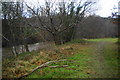
Path to Trehafren Park
The path follows the River Severn to the heart of Newtown, though a better path runs slightly further away from the river.
Image: © Bill Boaden
Taken: 15 Dec 2012
0.07 miles
2
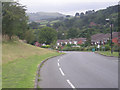
L?n Cerddyn, Newtown
From the A489 Llanidloes Road, Lôn Cerddyn leads to an area of housing on the south bank of the River Severn.
Image: © Jaggery
Taken: 1 Feb 2017
0.09 miles
4
L?n Ceirios, Newtown
Cul-de-sac viewed across Lôn Cerddyn, part of an area of housing between Llanidloes Road and the River Severn.
Image: © Jaggery
Taken: 1 Feb 2017
0.12 miles
5
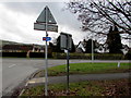
National Cycle Network Route 81 direction sign on a Newtown corner
The sign faces Lôn Cerddyn on the corner of the A489 Llanidloes Road.
National Cycle Network Route 81 connects Aberystwyth and Wolverhampton via Shrewsbury and Telford.
Image: © Jaggery
Taken: 1 Feb 2017
0.13 miles
6
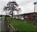
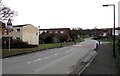
Row of bungalows, L?n Ceirios, Newtown
The fronts of bungalows viewed from the Llanidloes Road pavement.
The backs of the bungalows are alongside Lôn Ceirios.
Image: © Jaggery
Taken: 1 Feb 2017
0.15 miles
7
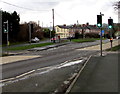
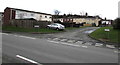
Llanidloes Road pelican crossing, Newtown
Across the A489 Llanidloes Road in the west of Newtown.
Chambers Dictionary states that pelican in this context is adapted from "pedestrian light controlled crossing".
Image: © Jaggery
Taken: 1 Feb 2017
0.15 miles
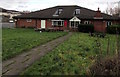
8
Llanidloes Road side of the Flying Shuttle, Newtown
The pub on the corner of Llanidloes Road and Heol Vaynor dates from the 1980s.
http://www.geograph.org.uk/photo/5269756 to a view of the Heol Vaynor side.
Image: © Jaggery
Taken: 1 Feb 2017
0.15 miles
9
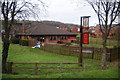
The Flying Shuttle, Newtown
I don't know how good this is as a pub, but it has a bus-stop named after it.
Image: © Bill Boaden
Taken: 15 Dec 2012
0.15 miles
10
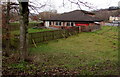
Path to the Flying Shuttle, Newtown
From Heol Vaynor below Llanidloes Road, the path leads to the Flying Shuttle, a pub dating from the 1980s.
Image: © Jaggery
Taken: 1 Feb 2017
0.15 miles