IMAGES TAKEN NEAR TO
Maisonettes, Garth Owen, NEWTOWN, SY16 1JQ
Introduction
This page details the photographs taken nearby to Maisonettes, Garth Owen, SY16 1JQ by members of the Geograph project.
The Geograph project started in 2005 with the aim of publishing, organising and preserving representative images for every square kilometre of Great Britain, Ireland and the Isle of Man.

There are currently over 7.5m images from over14,400 individuals and you can help contribute to the project by visiting https://www.geograph.org.uk
Image Map
Images are licensed for reuse under creativecommons.org/licenses/by-sa/2.0
Notes
- Clicking on the map will re-center to the selected point.
- The higher the marker number, the further away the image location is from the centre of the postcode.
Image Listing (63 Images Found)
Images are licensed for reuse under creativecommons.org/licenses/by-sa/2.0
Image
Details
Distance
1

Garthowen Shops, Plantation Lane, Newtown, Powys
The shops at Garthowen, Newtown, Powys
Image: © Henry Spooner
Taken: 27 May 2009
0.03 miles
3
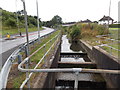
Stepped issue alongside Dolfor Road, Newtown
This water channel is shown on maps as an issue. The water descends steps to a conduit under Plantation Road and resurfaces about 100 metres behind the camera.
Image: © Jaggery
Taken: 4 Aug 2013
0.06 miles
4
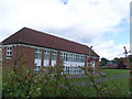
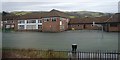
Newtown High School, Plantation Lane, Newtown, Powys
The main block of Newtown High School, Plantation Lane, Newtown, Powys.
Image: © Henry Spooner
Taken: 27 May 2009
0.06 miles
5
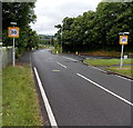
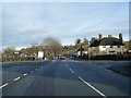
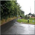
Start of the 30 zone and pavements in Newtown
Viewed along the A483 Dolfor Road. Upper Dolfor Road joins from the right.
The end of the grass verge and the start of pavements at the southern edge of Newtown
coincides with the reduction in the speed limit from the National Speed Limit to 30mph.
Image: © Jaggery
Taken: 4 Aug 2013
0.08 miles
6
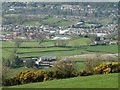
View from the ridge road to Dolfor
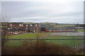
The farm nearest the camera is Bryneira with bypass works just below it and Cefnaire a little further away on the right.
The collection of large brick buildings left of centre is Newtown High School with the new Welsh medium primary school Ysgol Dafydd Llwyd (white roofs, partially hidden by the hill) to its right.
The large grey roof to the right of that is the Lidl store on Llanidloes Road (A489) and beyond that, Latham Park football ground. The houses between them are part of the Trehafren estate which surrounds the hill to the left of the football ground.
The houses near the top of the photo are across the river on or off Milford Road (B4568).
Image: © Penny Mayes
Taken: 26 Mar 2017
0.10 miles
8
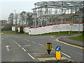
Newtown, Dolfor Road
New building under construction at the corner of Heol Treowen and Delfor Road. A sign on the hoarding states the Hope Church (Image]) has relocated.
Image: © David Dixon
Taken: 15 Apr 2016
0.11 miles
9
Upper Dolfor Road, Newtown
At the southern edge of Newtown, Upper Dolfor Road diverges from the A483 Dolfor Road. The circular sign with a red edge shows that vehicles weighing more than 7.5 tonnes are prohibited, except for access.
Image: © Jaggery
Taken: 4 Aug 2013
0.12 miles