IMAGES TAKEN NEAR TO
School Close, WHITCHURCH, SY13 4ND
Introduction
This page details the photographs taken nearby to School Close, SY13 4ND by members of the Geograph project.
The Geograph project started in 2005 with the aim of publishing, organising and preserving representative images for every square kilometre of Great Britain, Ireland and the Isle of Man.

There are currently over 7.5m images from over14,400 individuals and you can help contribute to the project by visiting https://www.geograph.org.uk
Image Map
Images are licensed for reuse under creativecommons.org/licenses/by-sa/2.0
Notes
- Clicking on the map will re-center to the selected point.
- The higher the marker number, the further away the image location is from the centre of the postcode.
Image Listing (28 Images Found)
Images are licensed for reuse under creativecommons.org/licenses/by-sa/2.0
Image
Details
Distance
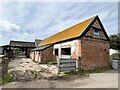
2
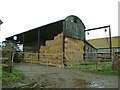
Crosshill Farm
An open-sided hay barn.
Image: © Stephen Craven
Taken: 16 Nov 2014
0.13 miles
3
The Swan at Marbury
Marbury. The Swan at Marbury PH. Highly recommended for a beer after a walk or for dining in the evening at a very high standard (and a reasonable price) for a country pub. Photographer has no connection, other than as a satisfied customer, with the establishment. The other images for this square give other reasons for a visit to Marbury!
Image: © Mike Harris
Taken: 2 Aug 2006
0.14 miles
4
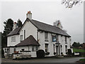
The Swan Inn, Marbury
The only public house in a small village, and it was very quiet when we went in on a Sunday afternoon.
Image: © Stephen Craven
Taken: 16 Nov 2014
0.14 miles
5
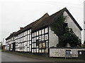
Wooden framed house, Marbury
The building is listed grade 2 (LEN 1312503); the listing describes it as a 17th century farm building, now used as an outhouse to the Swan Inn.
Image: © Stephen Craven
Taken: 16 Nov 2014
0.15 miles
6
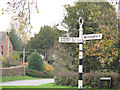
Signpost in the centre of Marbury village
The signpost stands at a triangular road junction, pointing to Wrenbury, Wirswall and Whitchurch.
Image: © Stephen Craven
Taken: 16 Nov 2014
0.15 miles
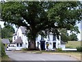
7
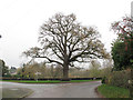
Tree in the centre of Marbury village
A large tree in the triangular road junction.
Image: © Stephen Craven
Taken: 16 Nov 2014
0.15 miles
8
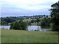
Big Mere, Marbury
Marbury. Big Mere from footpath NW of church. Most images of this mere are taken from the South Cheshire Way, which forms a popular route on the other side of the mere. This gives a different perspective, from the north side looking towards Buttermilk Bank.
Image: © Mike Harris
Taken: 2 Aug 2006
0.17 miles
9
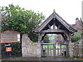
Church of St Michael, Marbury: war memorial lychgate
The lychgate was built in 1919 as a First World War memorial. It is grade 2 listed (LEN 1138496).
Image: © Stephen Craven
Taken: 16 Nov 2014
0.19 miles
10
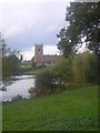
St Michael and All Angels, Marbury, with Marbury Mere in the foreground
Image: © Christopher Hilton
Taken: 23 Oct 2005
0.20 miles