IMAGES TAKEN NEAR TO
Wrexham Road, WHITCHURCH, SY13 1HP
Introduction
This page details the photographs taken nearby to Wrexham Road, SY13 1HP by members of the Geograph project.
The Geograph project started in 2005 with the aim of publishing, organising and preserving representative images for every square kilometre of Great Britain, Ireland and the Isle of Man.

There are currently over 7.5m images from over14,400 individuals and you can help contribute to the project by visiting https://www.geograph.org.uk
Image Map
Images are licensed for reuse under creativecommons.org/licenses/by-sa/2.0
Notes
- Clicking on the map will re-center to the selected point.
- The higher the marker number, the further away the image location is from the centre of the postcode.
Image Listing (133 Images Found)
Images are licensed for reuse under creativecommons.org/licenses/by-sa/2.0
Image
Details
Distance
1
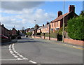
Wrexham Road, Whitchurch
Looking west along Wrexham Road from the corner of Liverpool Road.
Image: © Jaggery
Taken: 22 Oct 2015
0.01 miles
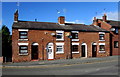
2
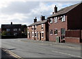
Along Highgate towards Wrexham Road, Whitchurch
The houses on the left are on the corner of Wrexham Road. http://www.geograph.org.uk/photo/4714272
Image: © Jaggery
Taken: 22 Oct 2015
0.03 miles
3
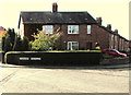
Road names in a Whitchurch hedge
Wrexham Road http://www.geograph.org.uk/photo/4714272 on the right is part of the route to Wrexham, about 20km away.
Liverpool Road http://www.geograph.org.uk/photo/4714290 on the left is not a route to Liverpool, but a dead-end road.
Image: © Jaggery
Taken: 22 Oct 2015
0.04 miles
4
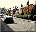
Liverpool Road, Whitchurch
Dead-end road leading to three other dead ends, Victoria Close, Hillewood Avenue and Mare Close.
Image: © Jaggery
Taken: 22 Oct 2015
0.05 miles
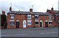
5
Row of houses, Highgate, Whitchurch
Alongside the B5476 Highgate, near the corner of the B5398 Wrexham Road, out of shot on the left.
The corner is the western end of the B5476, a 22km long route from the A528 at Harmer Hill.
Image: © Jaggery
Taken: 22 Oct 2015
0.05 miles
7
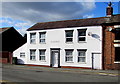
The Bakehouse, Highgate, Whitchurch
Former bakehouse nearly opposite the former Highgate Inn. http://www.geograph.org.uk/photo/4714217
Image: © Jaggery
Taken: 22 Oct 2015
0.06 miles
8
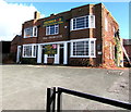
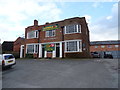
Former Highgate Inn, Whitchurch
The Discover Shropshire website states that, according to TC Duggan (1935), Highgate Inn was originally on the corner opposite Mill Street. It was rebuilt here in 1837. Accommodation in 1896 was given as 5 bedrooms, with stabling for 24 horses (day) and 16 (night). The building is now (2015) the head office and storage facility of the furniture removals firm Denmans.
Image: © Jaggery
Taken: 22 Oct 2015
0.06 miles
9
The former Highgate public house, Whitchurch
Now a self storage centre.
Image: © JThomas
Taken: 14 Mar 2019
0.07 miles
10
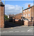
Scotland Street, Whitchurch
The SE end of a dead end street extending for 65 metres from Highgate.
Image: © Jaggery
Taken: 22 Oct 2015
0.07 miles