IMAGES TAKEN NEAR TO
Crewe Bank Yard, Castle Foregate, SHREWSBURY, SY1 2EB
Introduction
This page details the photographs taken nearby to Crewe Bank Yard, Castle Foregate, SY1 2EB by members of the Geograph project.
The Geograph project started in 2005 with the aim of publishing, organising and preserving representative images for every square kilometre of Great Britain, Ireland and the Isle of Man.

There are currently over 7.5m images from over14,400 individuals and you can help contribute to the project by visiting https://www.geograph.org.uk
Image Map
Images are licensed for reuse under creativecommons.org/licenses/by-sa/2.0
Notes
- Clicking on the map will re-center to the selected point.
- The higher the marker number, the further away the image location is from the centre of the postcode.
Image Listing (293 Images Found)
Images are licensed for reuse under creativecommons.org/licenses/by-sa/2.0
Image
Details
Distance
1
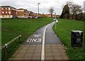
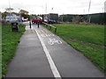
Footpath and cycle route towards Greenfields Gardens, Shrewsbury
From an industrial area on the west side of the A5191 Castle Foregate.
Image: © Jaggery
Taken: 1 Dec 2015
0.05 miles
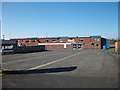
3
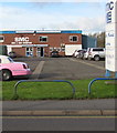
SMC music & audio superstore, Shrewsbury
Looking across the A5191 St Michael's Street past the boot of a pink stretch limo. http://www.geograph.org.uk/photo/4742806
Image: © Jaggery
Taken: 16 Nov 2015
0.07 miles
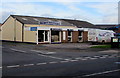
4
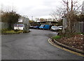
Entrance to Erect A Scaffold, Shrewsbury
Located in Crewe Bank Yard, accessed from Castle Foregate.
Image: © Jaggery
Taken: 1 Dec 2015
0.07 miles
6
Southern end of a cycle path from Greenfields Gardens, Shrewsbury
Greenfields Gardens is an area of modern housing http://www.geograph.org.uk/photo/4755181
which is accessed by motor vehicles from the A528 Ellesmere Road.
Image: © Jaggery
Taken: 1 Dec 2015
0.07 miles
7
Bob Smith Carpets & Beds shop and van, Shrewsbury
Located in St Michael's Street in the Castlefields area of Shrewsbury.
Image: © Jaggery
Taken: 16 Nov 2015
0.07 miles
8
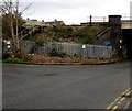
Railway bridge access steps, Shrewsbury
Giving authorised staff access to the railway adjacent to this http://www.geograph.org.uk/photo/4755144 bridge near Castle Foregate.
Image: © Jaggery
Taken: 1 Dec 2015
0.07 miles
9
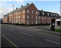
Simpson Square, Shrewsbury
Viewed across the northern end of the A5191 Castle Foregate which becomes the A5191 St Michael's Street nearby. Simpson Square is one of the newest residential blocks of flats in Shrewsbury. It occupies the site of Simpson’s Square, built c1810, demolished after the Second World War. John Simpson (1755-1815) was in charge of the rebuilding of St Chad's church http://www.geograph.org.uk/photo/4010162 in Shrewsbury in the 1790s.
Image: © Jaggery
Taken: 16 Nov 2015
0.08 miles
10
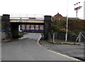
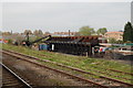
West side of a railway bridge near Castle Foregate, Shrewsbury
Looking towards Castle Foregate under a railway bridge on which a red-edged
triangular warning sign shows headroom of 13' 9". On the right are three of
many semaphore signals still in use in the Shrewsbury area in December 2015.
Image: © Jaggery
Taken: 1 Dec 2015
0.08 miles