IMAGES TAKEN NEAR TO
Rednal, West Felton, OSWESTRY, SY11 4FS
Introduction
This page details the photographs taken nearby to SY11 4FS by members of the Geograph project.
The Geograph project started in 2005 with the aim of publishing, organising and preserving representative images for every square kilometre of Great Britain, Ireland and the Isle of Man.

There are currently over 7.5m images from over14,400 individuals and you can help contribute to the project by visiting https://www.geograph.org.uk
Image Map
Images are licensed for reuse under creativecommons.org/licenses/by-sa/2.0
Notes
- Clicking on the map will re-center to the selected point.
- The higher the marker number, the further away the image location is from the centre of the postcode.
Image Listing (4 Images Found)
Images are licensed for reuse under creativecommons.org/licenses/by-sa/2.0
Image
Details
Distance
2
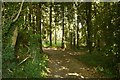
Woodhouse Coppice
The maps show a lot of buildings in here, no doubt part of what was RAF Rednal.
Image: © Richard Webb
Taken: 5 Jul 2018
0.17 miles
3
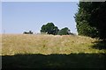
Woodland edge, Woodhouse
A field on the edge of what was RAF Rednal.
Image: © Richard Webb
Taken: 5 Jul 2018
0.17 miles
4
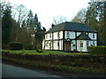
Woodhouse lodge
Woodhouse is a large house in the adjacent square - this substantial house is on one of the entrances to the park around the 'big house', so I assume it is a lodge for the estate.
Image: © David Medcalf
Taken: 10 Jan 2007
0.20 miles