IMAGES TAKEN NEAR TO
Trefonen, OSWESTRY, SY10 9DT
Introduction
This page details the photographs taken nearby to SY10 9DT by members of the Geograph project.
The Geograph project started in 2005 with the aim of publishing, organising and preserving representative images for every square kilometre of Great Britain, Ireland and the Isle of Man.

There are currently over 7.5m images from over14,400 individuals and you can help contribute to the project by visiting https://www.geograph.org.uk
Image Map
Images are licensed for reuse under creativecommons.org/licenses/by-sa/2.0
Notes
- Clicking on the map will re-center to the selected point.
- The higher the marker number, the further away the image location is from the centre of the postcode.
Image Listing (4 Images Found)
Images are licensed for reuse under creativecommons.org/licenses/by-sa/2.0
Image
Details
Distance
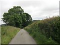
1
Bend in road at Moverhill Cottage
Moverhill Cottage is house on left
Image: © John Firth
Taken: 4 Jul 2013
0.01 miles
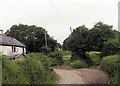
2
Lane at entrance to Plas Ucha
Plas Ucha is behind hedge - the roof can just be seen
Image: © John Firth
Taken: 4 Jul 2013
0.12 miles