IMAGES TAKEN NEAR TO
Maesbrook, OSWESTRY, SY10 8QD
Introduction
This page details the photographs taken nearby to SY10 8QD by members of the Geograph project.
The Geograph project started in 2005 with the aim of publishing, organising and preserving representative images for every square kilometre of Great Britain, Ireland and the Isle of Man.

There are currently over 7.5m images from over14,400 individuals and you can help contribute to the project by visiting https://www.geograph.org.uk
Image Map
Images are licensed for reuse under creativecommons.org/licenses/by-sa/2.0
Notes
- Clicking on the map will re-center to the selected point.
- The higher the marker number, the further away the image location is from the centre of the postcode.
Image Listing (5 Images Found)
Images are licensed for reuse under creativecommons.org/licenses/by-sa/2.0
Image
Details
Distance
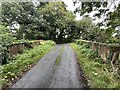
1
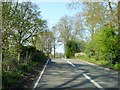
Bridge over old railway, west of Maesbrook
The redundant Llanymynech to Shrewsbury railway under the bridge has been dismantled
Image: © David Smith
Taken: 23 Apr 2015
0.07 miles
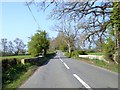
3
Bridge over railway
The Potts line from Shrewsbury to Llanymynech closed in 1961, but this bridge still survives.
Image: © John H Darch
Taken: 10 Sep 2024
0.18 miles
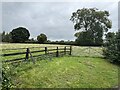
5
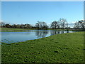
Floods at Llwyntidmon
The stream is some distance away - these are just waterlogged fields, though no doubt the stream contributes to that.
Image: © David Medcalf
Taken: 10 Jan 2007
0.24 miles