IMAGES TAKEN NEAR TO
Crickheath, OSWESTRY, SY10 8BP
Introduction
This page details the photographs taken nearby to SY10 8BP by members of the Geograph project.
The Geograph project started in 2005 with the aim of publishing, organising and preserving representative images for every square kilometre of Great Britain, Ireland and the Isle of Man.

There are currently over 7.5m images from over14,400 individuals and you can help contribute to the project by visiting https://www.geograph.org.uk
Image Map
Images are licensed for reuse under creativecommons.org/licenses/by-sa/2.0
Notes
- Clicking on the map will re-center to the selected point.
- The higher the marker number, the further away the image location is from the centre of the postcode.
Image Listing (4 Images Found)
Images are licensed for reuse under creativecommons.org/licenses/by-sa/2.0
Image
Details
Distance

3
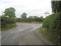
Crossroads just west of Crickheath
Looking North
Image: © John Firth
Taken: 5 Oct 2010
0.20 miles
4
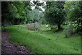
Some work to do here
The dry bed of the Montgomery Canal at Crickheath. The intention is to restore the entire canal route to Newtown with a target date for completion of 2029, subject to funding materializing; looking at this section, untouched since the canal was closed in 1936, there's a lot of work to do before reopening becomes a reality.
Image: © John Winder
Taken: 28 Jul 2019
0.24 miles