IMAGES TAKEN NEAR TO
Morton, OSWESTRY, SY10 8BD
Introduction
This page details the photographs taken nearby to SY10 8BD by members of the Geograph project.
The Geograph project started in 2005 with the aim of publishing, organising and preserving representative images for every square kilometre of Great Britain, Ireland and the Isle of Man.

There are currently over 7.5m images from over14,400 individuals and you can help contribute to the project by visiting https://www.geograph.org.uk
Image Map
Images are licensed for reuse under creativecommons.org/licenses/by-sa/2.0
Notes
- Clicking on the map will re-center to the selected point.
- The higher the marker number, the further away the image location is from the centre of the postcode.
Image Listing (39 Images Found)
Images are licensed for reuse under creativecommons.org/licenses/by-sa/2.0
Image
Details
Distance
1
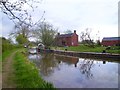
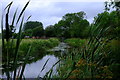
Gronwen Wharf
This lonely spot is the present end of navigation on the section of Montgomery canal that is connected to the main canal system. You can just make out the barrier under the bridge.
There is a small boatyard here on a short side arm, which is also where boats have to turn round.
Beyond the bridge the canal looks in very good order so maybe boats will be allowed through soon.
Image: © Des Blenkinsopp
Taken: 23 Apr 2012
0.01 miles
2
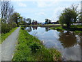
The Current limit of navigation on the Montgomery Canal
This winding hole is the current limit, the next winding hole will be Crickheath Wharf. Image]
Image: © John Haynes
Taken: 5 May 2016
0.01 miles
3
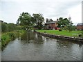
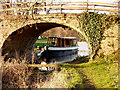
Gronwyn Wharf, Montgomery Canal
The current [2016] limit of navigation, at least for narrowboats. There is another mile in water Gronwyn Bridge [No 82] but no way of turning round.
Image: © Christine Johnstone
Taken: 18 Sep 2016
0.01 miles
4
Current limit of navigation on the Montgomery Canal
The section this side of the bridge has been restored and is now awaiting restoration to Crickheath.
Image: © John Haynes
Taken: 5 May 2016
0.01 miles
5
View through the bullrushes
Looking back at the current limit of navigation on the Montgomery Canal. The section pictured here is actually in water for another few hundred yards, having been restored and refilled recently, but is not yet open to navigation. See John Haynes' picture Image], taken nearby in 2007 during restoration work.
Image: © John Winder
Taken: 28 Jul 2019
0.01 miles
6
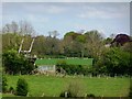
The Current Limit of Navigation
The Montgomery Canal, ran from Lower Frankton on the Wales / England border southward to Newtown in Powys. A major restoration project is slowly seeing this canal returned as a navigable waterway. Gronwen Wharf, pictured above, is the current limit to navigation from the main canal network. There is also a fully restored length of the canal north and south from Welshpool. Image]
Image: © John Haynes
Taken: 25 Feb 2005
0.04 miles
7
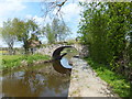
Lift bridge on the Montgomery Canal
Almost lost in the green fields of the Morda valley.
Image: © Christine Johnstone
Taken: 9 May 2010
0.04 miles
8
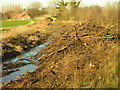
Restoration work in progress on Montgomery branch of Shropshire Union Canal
Image: © David Hancock
Taken: 25 Jan 2007
0.06 miles
9
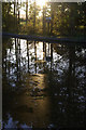
Montgomery Canal, Maesbury
The low evening sun creates reflections on the last stretch of water before the current limit of navigation at Gronwyn Bridge, seven miles from Frankton Junction.
Image: © Stephen McKay
Taken: 5 Oct 2008
0.07 miles
10
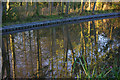
Montgomery Canal, Maesbury
Canalside trees are perfectly reflected in the water between Crofts Mill bridge and Gronwyn Bridge.
Image: © Stephen McKay
Taken: 5 Oct 2008
0.09 miles