IMAGES TAKEN NEAR TO
Fir Grove Road, LONDON, SW9 7EW
Introduction
This page details the photographs taken nearby to Fir Grove Road, SW9 7EW by members of the Geograph project.
The Geograph project started in 2005 with the aim of publishing, organising and preserving representative images for every square kilometre of Great Britain, Ireland and the Isle of Man.

There are currently over 7.5m images from over14,400 individuals and you can help contribute to the project by visiting https://www.geograph.org.uk
Image Map
Images are licensed for reuse under creativecommons.org/licenses/by-sa/2.0
Notes
- Clicking on the map will re-center to the selected point.
- The higher the marker number, the further away the image location is from the centre of the postcode.
Image Listing (85 Images Found)
Images are licensed for reuse under creativecommons.org/licenses/by-sa/2.0
Image
Details
Distance
1

Houses in Overton Rd
This is the back of the houses on the west side of Overton Rd seen through the trees of the small park that lies between it and the Brixton Rd which is just out of picture to the left. I summer the houses are not visible at all due to leaves on the trees
Image: © Nigel Mykura
Taken: 5 Mar 2013
0.07 miles
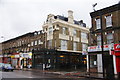
2
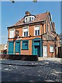
Brixton Jamm
Brixton Jamm has been a 18th century inn, a 19th century public house (Ye Old White Horse) and now a multi-purpose music venue with club nights, bar and an outdoor terrace space.
Image: © PAUL FARMER
Taken: 15 May 2019
0.08 miles
3
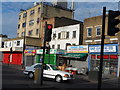
Shops at the corner of Loughborough Road and Brixton Road
Image: © Bikeboy
Taken: 24 Jul 2013
0.10 miles
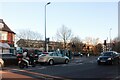
5
Max Roach Park, Brixton Road (A23)
Corner of Loughborough Road, it's the start of the Brixton Tree Trail.
Image: © Noel Foster
Taken: 5 Sep 2005
0.11 miles
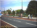
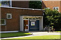
6
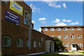
Iveagh Health Centre, Loughborough Road
A splendid 1950s building, capturing that optimistic moment of welfare state modernism.
Image: © Christopher Hilton
Taken: 1 Jul 2011
0.13 miles
7
Iveagh Health Centre, Loughborough Road
A splendid 1950s building, capturing that optimistic moment of welfare state modernism.
Image: © Christopher Hilton
Taken: 1 Jul 2011
0.13 miles
8
Iveagh Health Centre, Loughborough Road
A splendid 1950s building, capturing that optimistic moment of welfare state modernism.
Image: © Christopher Hilton
Taken: 1 Jul 2011
0.13 miles
9
Iveagh Health Centre, Loughborough Road
A splendid 1950s building, capturing that optimistic moment of welfare state modernism.
Image: © Christopher Hilton
Taken: 1 Jul 2011
0.13 miles
10
Crown & Anchor, Brixton
A pub listed in the Good Beer Guide. There are not many competitors locally.
Image: © Bill Boaden
Taken: 31 Jan 2014
0.13 miles