IMAGES TAKEN NEAR TO
Heath Road, LONDON, SW8 3BD
Introduction
This page details the photographs taken nearby to Heath Road, SW8 3BD by members of the Geograph project.
The Geograph project started in 2005 with the aim of publishing, organising and preserving representative images for every square kilometre of Great Britain, Ireland and the Isle of Man.

There are currently over 7.5m images from over14,400 individuals and you can help contribute to the project by visiting https://www.geograph.org.uk
Image Map (125 Images)


Getting Data...Please wait
Leaflet Map data © OpenStreetMap
Images are licensed for reuse under creativecommons.org/licenses/by-sa/2.0
Notes
- Clicking on the map will re-center to the selected point.
- The higher the marker number, the further away the image location is from the centre of the postcode.
Image Listing (125 Images Found)
Images are licensed for reuse under creativecommons.org/licenses/by-sa/2.0
Image
Details
Distance
1
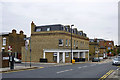
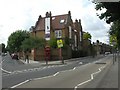
Building on Silverthorne Road, SW8
Now all flats, it is hard to work out whether it once had shops on the ground floor. Each division has steps down to basement level flats as well up to a level higher than ground.
Image: © Robin Webster
Taken: 6 May 2012
0.06 miles
2
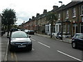
Battersea, Robertson Street
Side street between Queenstown & Silverthorne Roads, also forming the boundary between Lambeth (on the left) and Wandsworth (on the right).
Image: © Mike Faherty
Taken: 22 Aug 2009
0.06 miles
4
House for sale, Silverthorne Road
Wedged between Robertson Street and Thackeray Road, this has the honour of bearing a period Borough of Battersea street name plate. This is probably because the local authority boundary, now between Lambeth and Wandsworth, runs along Robertson Street on the left.
Image: © Robin Webster
Taken: 6 May 2012
0.07 miles
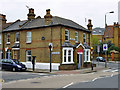
5
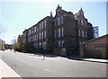
Battersea, converted school
At the junction of Silverthorne Road & Thackeray Street, in the Diamond Conservation Area; previously Thackeray Primary School, now housing. A tablet calls it"Domestic Economy School".
Image: © Mike Faherty
Taken: 22 Aug 2009
0.08 miles
6
Clapham, Heathbrook Primary School
On St Rule Street: http://webfronter.com/lambeth/heathbrook/
Image: © Mike Faherty
Taken: 20 Apr 2013
0.08 miles
7
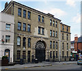
Former Plough Brewery, Wandsworth Road
Dating from c1870. Grade II listed.
Now offices.
Image: © Stephen Richards
Taken: 21 Apr 2013
0.08 miles
8
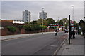
London : Lambeth - Wandworth Road
Looking along Wandsworth Road as it heads through Lambeth.
Image: © Lewis Clarke
Taken: 23 Oct 2014
0.08 miles
9
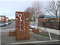
St. Rules Street, Wandsworth
Several places in Wandsworth seem to be marked by these large rusted metal artwork. This one is in the middle of the road, near the junction with Robertson Street.
Image: © David Anstiss
Taken: 30 Dec 2012
0.08 miles
10
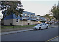
Housing on the Westbury Estate in Lambeth
Image: © Rod Allday
Taken: 7 Oct 2016
0.08 miles