IMAGES TAKEN NEAR TO
Gloucester Road, LONDON, SW7 4RA
Introduction
This page details the photographs taken nearby to Gloucester Road, SW7 4RA by members of the Geograph project.
The Geograph project started in 2005 with the aim of publishing, organising and preserving representative images for every square kilometre of Great Britain, Ireland and the Isle of Man.

There are currently over 7.5m images from over14,400 individuals and you can help contribute to the project by visiting https://www.geograph.org.uk
Image Map
Images are licensed for reuse under creativecommons.org/licenses/by-sa/2.0
Notes
- Clicking on the map will re-center to the selected point.
- The higher the marker number, the further away the image location is from the centre of the postcode.
Image Listing (262 Images Found)
Images are licensed for reuse under creativecommons.org/licenses/by-sa/2.0
Image
Details
Distance
1
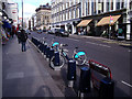
Gloucester Road docking station
Only two bikes available on a Saturday lunchtime at this docking station in Kensington.
Image: © Stephen Craven
Taken: 22 Feb 2014
0.01 miles
2
East on Kynance Mews east, Knightsbridge
Looking towards Gloucester Road.
Image: © Robin Stott
Taken: 22 Feb 2014
0.03 miles
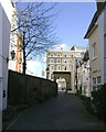
4
Kynance Place
Running west from Gloucester Road, to the north of Kynance Mews, with Christ Church http://www.christchurchkensington.com/ steeple in the background.
Note the white range of buildings (7-10 Kynance Place) on the left which has widening walls to match the diverging street pattern of Kynance Place and Kynance Mews.
For a view of the white buildings from inside Kynance Mews see Image
Image: © Roger Jones
Taken: 22 Feb 2014
0.03 miles
5
East side of Launceston Place, Knightsbridge
Image: © Robin Stott
Taken: 22 Feb 2014
0.04 miles
6
Kynance Mews, SW7
Off Gloucester Road.
Image: © Robin Webster
Taken: 22 Apr 2018
0.04 miles
7
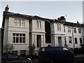
No.33 and No.34 Launceston Place, South Kensington
Two houses (part of a row of Grade II listed houses including No.s 23-34).
See http://www.britishlistedbuildings.co.uk/en-421707-23-34-kensington for more details about the row of houses.
Image: © David Anstiss
Taken: 18 Dec 2011
0.04 miles
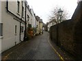
9
Petersham Lane
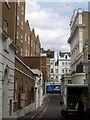
Delivery time in a small London back street. Petersham Lane, which gives access to Petersham Place just beyond the first van, runs parallel to Gloucester Road on the left. Beyond the blue lorry is Queen's Gate Terrace.
Image: © Derek Harper
Taken: 31 Jul 2009
0.04 miles
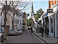
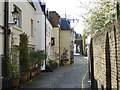
10
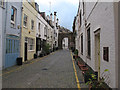
Kynance Mews (East) looking West
Looking towards Launceston Place and the listed archway.
Image: © Roger Jones
Taken: 15 Jan 2013
0.04 miles