IMAGES TAKEN NEAR TO
Cloncurry Street, LONDON, SW6 6DU
Introduction
This page details the photographs taken nearby to Cloncurry Street, SW6 6DU by members of the Geograph project.
The Geograph project started in 2005 with the aim of publishing, organising and preserving representative images for every square kilometre of Great Britain, Ireland and the Isle of Man.

There are currently over 7.5m images from over14,400 individuals and you can help contribute to the project by visiting https://www.geograph.org.uk
Image Map
Images are licensed for reuse under creativecommons.org/licenses/by-sa/2.0
Notes
- Clicking on the map will re-center to the selected point.
- The higher the marker number, the further away the image location is from the centre of the postcode.
Image Listing (187 Images Found)
Images are licensed for reuse under creativecommons.org/licenses/by-sa/2.0
Image
Details
Distance
2
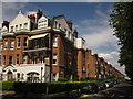
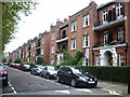
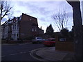
Bishops Park Road, Fulham
At the corner of Stevenage Road (left) and at the entrance to Bishops Park (behind camera). These rather grand semis are each divided into six (on Bishops Park Road) and eight (on Stevenage Road) flats.
Image: © Derek Harper
Taken: 3 Aug 2012
0.09 miles
3
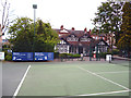
Fulham: Tennis grounds in Bishops Park
Image: © Dr Neil Clifton
Taken: 17 May 2013
0.09 miles
4
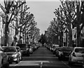
Ellerby Street
Pollarded trees on Ellerby Street near Craven Cottage in Fulham.
Image: © Peter McDermott
Taken: 7 Mar 2015
0.09 miles
5
Woodlawn Road at the corner of Ellerby Street
Image: © David Howard
Taken: 20 Jan 2014
0.10 miles
6
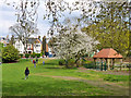
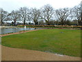
Bishops Park
A public area along the river bank.
Image: © Robin Webster
Taken: 14 Apr 2012
0.10 miles
7
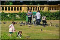
Fulham : Bishops Park
Looking across Bishops Park to people in the park feeding pigeons.
Image: © Lewis Clarke
Taken: 27 Jun 2022
0.11 miles
9
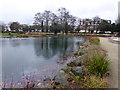
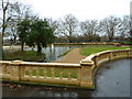
The lake in Bishop's Park
The adjacent river wall was built in three stages between 1893 and 1903 to the designs of Joseph Mears, the Borough Surveyor. The wall was built entirely of concrete and faced with rusticated concrete blocks. Once the river wall had been constructed, the area behind had to be filled in so local builders were invited to 'shoot at the Bishops' - that is to dump all manner of waste, so that the site could be levelled and grassed - see https://www.geograph.org.uk/photo/6028020 for a photograph of the river wall.
That part of the park was then designed in 1903 by the Surveyor and Chief Engineer of Fulham Borough Council. The sweeping lake in Bishop's Park was enclosed on two sides by terracotta balustrading engraved with the monogram and crest of Fulham Borough Council.The rustic timber bridge gave access to a picnic and croquet lawn which was later turned into a small bowling green.The islands were the home to swans which were given by King Edward VIIth.
The original form of the lake has now been restored and the rustic bridge, which was originally of timber, has now been recreated in more durable cast iron. The picnic area has been returned to lawn.
Image: © Marathon
Taken: 16 Jan 2019
0.11 miles