IMAGES TAKEN NEAR TO
Wandsworth Bridge Road, LONDON, SW6 2TX
Introduction
This page details the photographs taken nearby to Wandsworth Bridge Road, SW6 2TX by members of the Geograph project.
The Geograph project started in 2005 with the aim of publishing, organising and preserving representative images for every square kilometre of Great Britain, Ireland and the Isle of Man.

There are currently over 7.5m images from over14,400 individuals and you can help contribute to the project by visiting https://www.geograph.org.uk
Image Map (Loading...)


Getting Data...Please wait
Leaflet Map data © OpenStreetMap
Images are licensed for reuse under creativecommons.org/licenses/by-sa/2.0
Notes
- Clicking on the map will re-center to the selected point.
- The higher the marker number, the further away the image location is from the centre of the postcode.
Image Listing (84 Images Found)
Images are licensed for reuse under creativecommons.org/licenses/by-sa/2.0
Image
Details
Distance
1
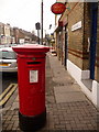
Fulham: Wandsworth Bridge Road Post Office and postbox № SW6 16
Although the name of this post office matches its address of 317 Wandsworth Bridge Road, its frontage faces entirely onto Hugon Road, just around the corner. The postbox, a large George V-reign specimen, is emptied finally at 5:30pm on weekdays and at noon on Saturdays.
Image: © Chris Downer
Taken: 11 Jan 2010
0.01 miles
2
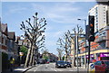
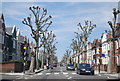
Pollarded trees, A217
The trees are London Planes (Platanus 'Ely')
Image: © N Chadwick
Taken: 26 May 2013
0.02 miles
3
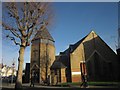
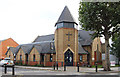
St Matthew's Church, Wandsworth Bridge Road
At the corner of Rosebury Road (left). The church, rebuilt in 2000, retains five stained glass panels from the 1895 church it replaced on this site.
Image: © Derek Harper
Taken: 10 Dec 2011
0.02 miles
4
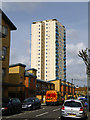
Barton House, SW6
High-rise flats, with the main pedestrian entrance on Wandsworth Bridge Road.
Image: © Robin Webster
Taken: 14 Apr 2012
0.03 miles
5
St Matthew, Wandsworth Bridge Road, Fulham
Image: © John Salmon
Taken: 17 Oct 2013
0.04 miles
6
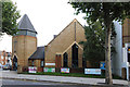
St Matthew, Wandsworth Bridge Road, Fulham
Image: © John Salmon
Taken: 17 Oct 2013
0.04 miles
7
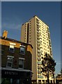
Barton House SW6
A view of the 76-flat block shown in Image, from further northwest along Wandsworth Bridge Road. In the foreground is a convenience store.
Image: © Derek Harper
Taken: 14 Oct 2011
0.04 miles
9
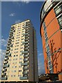
High rise on Wandsworth Bridge Road
Cairns House (right) is a relatively new arrival on the Townmead Estate north of Wandsworth Bridge. On the left is Barton House, a 20-storey block from the sixties.
Image: © Derek Harper
Taken: 12 Jun 2010
0.05 miles
10
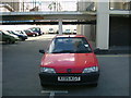
Barton House car park, SW6
An underground car-park of sorts in the basement of a towerblock,
Barton House at the bottom of Wandsworth Bridge Road.
Image: © Phillip Perry
Taken: 15 Jun 2007
0.07 miles