IMAGES TAKEN NEAR TO
Hamble Street, LONDON, SW6 2RT
Introduction
This page details the photographs taken nearby to Hamble Street, SW6 2RT by members of the Geograph project.
The Geograph project started in 2005 with the aim of publishing, organising and preserving representative images for every square kilometre of Great Britain, Ireland and the Isle of Man.

There are currently over 7.5m images from over14,400 individuals and you can help contribute to the project by visiting https://www.geograph.org.uk
Image Map
Images are licensed for reuse under creativecommons.org/licenses/by-sa/2.0
Notes
- Clicking on the map will re-center to the selected point.
- The higher the marker number, the further away the image location is from the centre of the postcode.
Image Listing (121 Images Found)
Images are licensed for reuse under creativecommons.org/licenses/by-sa/2.0
Image
Details
Distance
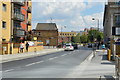
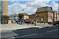
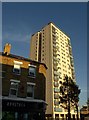
1
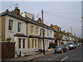
Hamble Street, Sands End
Victorian houses on a street running northwest off Townmead Road. Peering over the rooftops is the 20-storey Barton House on Stephendale Road.
Image: © Derek Harper
Taken: 14 Oct 2006
0.03 miles
2
Barton House car park, SW6
An underground car-park of sorts in the basement of a towerblock,
Barton House at the bottom of Wandsworth Bridge Road.
Image: © Phillip Perry
Taken: 15 Jun 2007
0.04 miles
5
Barton House, SW6
High-rise flats, with the main pedestrian entrance on Wandsworth Bridge Road.
Image: © Robin Webster
Taken: 14 Apr 2012
0.07 miles
6
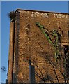
Pulley, Townmead Road
An old pulley survives on a derelict warehouse at Fulham Wharf, overlooking Townmead Road.
Image: © Derek Harper
Taken: 17 Apr 2008
0.07 miles
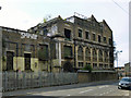
7
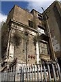
Derelict building , Townmead Road
Another view of the former Kops Brewery building on Fulham Wharf, shown in Image, and which has been purchased by Sainsbury's, who have a supermarket next door. The building dates from 1890. Some interior shots at http://www.28dayslater.co.uk/forums/showthread.php?p=588062 .
Image: © Derek Harper
Taken: 14 Apr 2010
0.07 miles
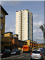
8
Barton House SW6
A view of the 76-flat block shown in Image, from further northwest along Wandsworth Bridge Road. In the foreground is a convenience store.
Image: © Derek Harper
Taken: 14 Oct 2011
0.07 miles
9
Part of the former Kop's Brewery
Now derelict, it was used for more general warehousing after closing as a brewery.
Image: © Robin Webster
Taken: 14 Apr 2012
0.08 miles