IMAGES TAKEN NEAR TO
Cedarne Road, LONDON, SW6 2DF
Introduction
This page details the photographs taken nearby to Cedarne Road, SW6 2DF by members of the Geograph project.
The Geograph project started in 2005 with the aim of publishing, organising and preserving representative images for every square kilometre of Great Britain, Ireland and the Isle of Man.

There are currently over 7.5m images from over14,400 individuals and you can help contribute to the project by visiting https://www.geograph.org.uk
Image Map
Images are licensed for reuse under creativecommons.org/licenses/by-sa/2.0
Notes
- Clicking on the map will re-center to the selected point.
- The higher the marker number, the further away the image location is from the centre of the postcode.
Image Listing (227 Images Found)
Images are licensed for reuse under creativecommons.org/licenses/by-sa/2.0
Image
Details
Distance
1
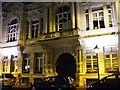
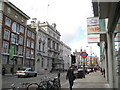
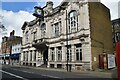
Fulham Town Hall, SW6
One of 2 entrances of Fulham Town Hall, this one is in Harwood Road.
Image: © Phillip Perry
Taken: 6 Nov 2008
0.02 miles
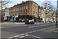
2
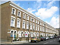
Fulham: Cedarne Road, SW6
This very neat and regular block of Victorian townhouses is off Fulham Broadway to its south. The Ordnance Survey map edition of 1869 shows them as being present with probably an identical block on the other side of the road which has since been demolished, possibly as the result of bomb damage as they were present in the 1938 edition of the mapping. The road name on the 1869 map, and on each successive edition up to and including the one of 1938, is definitely Cedar Road, so the change to Cedarne is comparatively recent.
Image: © Nigel Cox
Taken: 22 Jun 2008
0.03 miles
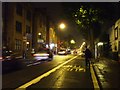
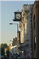
5
Fulham Broadway and Fulham Town Hall
The Underground roundel marks the entrance to Fulham Broadway station while the white building with the flagstaff over to the left is Fulham Town Hall. It was built as Fulham Vestry Hall between 1888 and 1890 to the designs of George Edwards who was the winner of a design competition. It later became the Town Hall, with an extension to the right being built in 1934, but thereby destroying its symmetry. It is not in local government use any more but is now a concert and dance venue.
Image: © Nigel Cox
Taken: 22 Jun 2008
0.04 miles
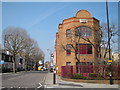
6
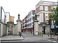
Fulham: The Sir Oswald Stoll Foundation memorial gate
Please see Image
This is the memorial gateway on the west side of the building. In the tablet of the left gatepost are recorded various naval events of the First World War, Heligoland Bight, Falkland Islands, Dogger Bank, Jutland Bank, and the Surrender of the German Navy, while the tablet in the right gatepost records infantry battles at Mons, Marne, Aisne, Ypres, Festubert, Somme, Ancre, Arras, Messines, Cambrai, Queant and Le Cateau.
Image: © Nigel Cox
Taken: 22 Jun 2008
0.04 miles
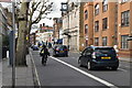
10
Fulham Town Hall
This Harwood Road facade, shown more clearly in Image, dates from 1905 http://www.britishlistedbuildings.co.uk/en-201793-fulham-town-hall-fulham .
Image: © Derek Harper
Taken: 14 Oct 2011
0.05 miles