IMAGES TAKEN NEAR TO
Columbia Gardens, LONDON, SW6 1FY
Introduction
This page details the photographs taken nearby to Columbia Gardens, SW6 1FY by members of the Geograph project.
The Geograph project started in 2005 with the aim of publishing, organising and preserving representative images for every square kilometre of Great Britain, Ireland and the Isle of Man.

There are currently over 7.5m images from over14,400 individuals and you can help contribute to the project by visiting https://www.geograph.org.uk
Image Map
Images are licensed for reuse under creativecommons.org/licenses/by-sa/2.0
Notes
- Clicking on the map will re-center to the selected point.
- The higher the marker number, the further away the image location is from the centre of the postcode.
Image Listing (331 Images Found)
Images are licensed for reuse under creativecommons.org/licenses/by-sa/2.0
Image
Details
Distance
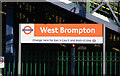
1
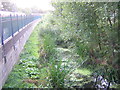
Wildlife garden, next to West Brompton station
Tucked in beside the northbound Overground platform is this wildlife area, currently (autumn 2011) being worked on by volunteers to make it ready for use by local schoolchildren.
The West London Line follows the route of one of London's lost rivers, Counter's Creek (the bottom 2 miles of which were made navigable in the 19th century as the Kensington Canal; the dock at Lots Road is the only surviving stretch of this). This ditch, as it should probably be called, is probably a small survival of the canal.
Image: © Christopher Hilton
Taken: 6 Oct 2011
0.01 miles
2
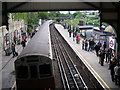
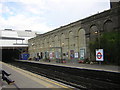
West Brompton station - an under-used interchange
This photograph shows the London Transport District Line station, with a southbound train of D78 stock just departing for Wimbledon. To the right is the main line station, which was closed in 1940 and later demolished, but in the late 1990s it was rebuilt and reopened. It now has an hourly service each way from Brighton to Watford Junction, and a half-hourly service from Clapham Junction to Willesden Junction. If more passengers were aware of the convenience of this interchange, it would see much heavier use.
Image: © Dr Neil Clifton
Taken: 25 May 2006
0.02 miles
3
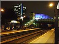
West Brompton Station
With the Empress building and Earls Court 2 lit up in the background
Image: © Martyn Davies
Taken: 17 Oct 2006
0.02 miles
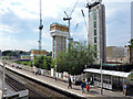
4
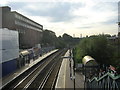
West Brompton station: the Overground lines, looking south
Image: © Christopher Hilton
Taken: 16 Sep 2011
0.02 miles
5
London has a new railway!
No, I am not referring to the new Eurostar terminal at St. Pancras, which opened the day before this photograph was taken. It's not really a NEW railway quite yet, but as from Sunday 11 November 2007, a whole group of National Rail lines in the London area were vested in Transport for London, which has collectively named them the London Overground. New signs like the one above will soon be appearing all over these lines and the colour selected is orange. New lines will follow by 2010 when the East London extensions are finished. and there will be new modern rolling stock throughout. Meanwhile there will be service improvements and all of the stations will be staffed throughout their opening hours.
Image: © Dr Neil Clifton
Taken: 15 Nov 2007
0.03 miles
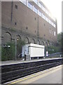
6
West Brompton railway station
Viewed from the Lillie Road bridge.
Image: © Thomas Nugent
Taken: 5 Jun 2015
0.03 miles
8
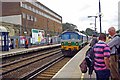
West Brompton Overground Station
The normal way to get to Image these days is via the Overground service as the district line exhibition service from earls court does not normally run these days. The loco is a class 66 Freightliner see http://www.therailwaycentre.com/Pages%20Loco/Recognition%20loco/Illus_66.html
Image: © Glyn Baker
Taken: 7 Aug 2012
0.03 miles
10
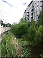
Counters Creek (or the Kensington Canal?) by West Brompton station
Leaving West Brompton station after travelling for the very first time on the West London line, I looked over my shoulder and noticed this body of water and the old seed-heads of reed mace - bullrushes. As a schoolboy I had (for seven years) travelled into town on the District Line, and in those days there were railway sidings here - where the tall block of flats now stands. I'd never suspected that there was a watercourse here, between the station and sidings - there hardly seemed to be room.
As for the identity of this body of water, Geograph came to the rescue - in the person of Christopher Hilton. He doesn't seem to have seen this stretch of water, but spotted the remains of a bridge a little further north. Image He also suggests that the same watercourse is known as Chelsea Creek where it reaches the Thames:
Image
A quick look at a map or two suggests that the boundary between the old boroughs of Fulham (to the west) and Kensington and Chelsea runs along Counters Creek from here right down to the Thames. It's a hypothesis I need to look at in more detail.
Incidentally, along the Thames the name 'creek' generally denotes a tidal tributary. It's a bizarre thought, but is it possible that the tide once flowed under the Old Brompton Road?
Image: © Stefan Czapski
Taken: 13 Aug 2021
0.04 miles