IMAGES TAKEN NEAR TO
Hogarth Road, LONDON, SW5 0QJ
Introduction
This page details the photographs taken nearby to Hogarth Road, SW5 0QJ by members of the Geograph project.
The Geograph project started in 2005 with the aim of publishing, organising and preserving representative images for every square kilometre of Great Britain, Ireland and the Isle of Man.

There are currently over 7.5m images from over14,400 individuals and you can help contribute to the project by visiting https://www.geograph.org.uk
Image Map
Images are licensed for reuse under creativecommons.org/licenses/by-sa/2.0
Notes
- Clicking on the map will re-center to the selected point.
- The higher the marker number, the further away the image location is from the centre of the postcode.
Image Listing (374 Images Found)
Images are licensed for reuse under creativecommons.org/licenses/by-sa/2.0
Image
Details
Distance
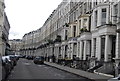
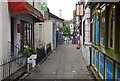
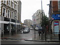
1
Kenway Road, SW5
A nice quiet little side street off of Earls Court Road.
Image: © Phillip Perry
Taken: 10 Aug 2010
0.02 miles
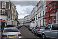
2
Kenway Road, Kensington, London
This is the 1937 'rebuilt' version of The King's Head public house. Records however, show that the earliest version of it was established in the C17th century. The area in front of the pub is known locally as Hogarth Place although the road on the right hand side of it - and the remainder of it that continues onwards behind the photographer - is Kenway Road. A narrow thoroughfare on the left of it provides pedestrians with access to Hogarth Road.
Image: © David Hallam-Jones
Taken: 30 Dec 2014
0.03 miles
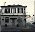
3
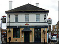
The King's Head, Earl's Court
This pub at the junction of Kenway Road and Hogarth Place, just off Earl's Court Road, has been a Fullers pub since 2015 when it was acquired from Faucet Inns. Note the signs depicting George V in a postage stamp style. There have been licensed premises here since the 17th century but the pub was rebuilt in 1937. See Image for how it looked before it came into Fullers ownership.
Image: © Stephen McKay
Taken: 22 Apr 2022
0.03 miles
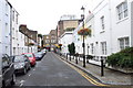
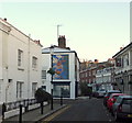
5
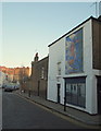
Wallgrave Road, Kensington, London
Opposite one side of The King's Head pub - behind the photographer - is the 'open' end of Wallgrave Road (a cul-de-sac). The painting of the angel pouring water into a tiered fountain is on the side of 35 Kenway Road, a 3-storey terrace, built c.1807. Willie Rushton lived on Wallgrave Road.
Image: © David Hallam-Jones
Taken: 30 Dec 2014
0.03 miles
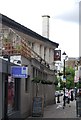
8
Kenway Road, Kensington, London
With the A3220 (Earl's Court Road) behind the photographer, this is the mid-point along Kenway Road. Once past the side of The King's Head pub - on the right - the road broadens out in front of the pub forming an area known locally as Hogarth Place, despite the fact that it is actually part of Kenway Road. The painting of the angel pouring water into a tiered fountain is on the side of No. 35 Kenway, Road, a 3-storey terrace built c.1807. The road branching off to the left is Wallgrave Road, where Willie Rushton once lived.
Image: © David Hallam-Jones
Taken: 30 Dec 2014
0.04 miles